
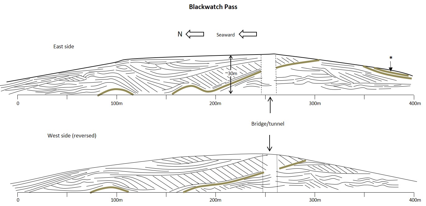
Blackwatch Pass cross section
Introduction
Blackwatch Pass is a deep road-cut which connects Bermuda’s North Shore Road to the City of Hamilton. It was excavated through a large dune ridge mapped as a member of the Rocky Bay formation (VA6). The exposed rock-faces feature a variety of undulating and planar aeolian strata.
The dune ridge at Blackwatch Pass largely accumulated during two dune-building phases, referred to here as Episode 1 and Episode 2. The respective aeolian deposits are separated by a prominent immature soil, known as a protosol (shown as a green line) which records a significant pause in aeolian deposition. A younger protosol seen at the southern end of the east-side section (marked with an asterisk) represents the end of Episode 2, after which little deposition occurred at this locality.
Through a dating process known as amino acid racemization (AAR), applied to fossil land snails, the youngest protosol here has been correlated with the Harrington protosol of the Rocky Bay Formation, and attributed an age of approximately 120,000 years. The underlying dune ridges of Episodes 1 and 2, although older, are considered to be the product of the same interglacial period (MIS 5e) as this protosol. For stratigraphic purposes all of the deposits exposed in Blackwatch Pass are considered contemperaneous and are assigned to the Rocky Bay Formation.
Dune-building episodes
Beneath the uppermost protosol are two dune ridges separated by a more prominent protosol, which generally dips down towards the north and locally disappears below the road surface.
The older dune ridge, of Episode 1, formed in a more landward position than the onlapping ridge of Episode 2 . Its development began with an influx of sand from the presently submerged platform to its north, possibly triggered by a fall in sea level. A moderate rate of sediment supply is represented by the formation of hummocky foredunes at a low elevation , below road level, towards the seaward end of the Pass. This was interpreted from a ground penetrating radar study (RO6). A decline in sediment supply ultimately resulted in stabilisation of Episode 1 dunes and the development of the overlying protosol, concomitant with the establishment of vegetation cover.
Episode 2 dunes formed on the northern, seaward, flank of the Episode 1 dune ridge. Of the two episodes, Episode 2 is responsible for accumulation of the larger volume of aeolian sand. It represents a phase of renewed sediment supply, which overcame the stabilising effect of vegetation cover on the Episode 1 dunes. A striking feature of Episode 2 deposits is the development of a long tongue of steeply dipping slip-face strata, which records the landward advance of a mobile “transgressive” dune.
Sea level influences on dune building
Minor sea level oscillations are widely accepted as stimulants for the mobilisation of coastal sediments which precedes dune-building (CO1, LE1, BI1). Rising sea levels encourage reef growth and generate sediment through erosion of shoreline cliffs. Falling sea levels cause the demise of the coral reefs as they become exposed above sea level. Erosion of the decaying reefs contributes to the accumulation of bioclastic carbonate sand which, as the sea recedes, is exposed to the wind.
Minor sea-level cycles within the same interglacial period, cause alternating phases of reef growth and erosion. Accommodation space on the platform starts to be filled by marine sands as sea level peaks, but beaches remain narrow. As sea level falls, sediment is reworked into wide, dissipative, beaches which supply sand to coastal dunes. Potentially, two such sea-level cycles are represented by the two episodes of dune building recorded in the geological record at Blackwatch Pass.
Environmental factors at play
Increases in sand supply and in vegetation cover have opposing effects on dune growth and mobility. A change in the balance in favour of the former results in instability and landward migration of coastal dunes. Whereas increased vegetation cover causes dune stabilisation and ultimately inactivity. Some natural factors, not related to sea level change, that can impact vegetation and sand supply, and therefore dune-building activity, are long-term weather patterns, individual severe storms and forest fires.
It is uncertain as to whether the two main episodes of dune building recorded in Blackwatch Pass were allogenic in origin – being driven cyclical global climate change or were autogenic – being related more to local environmental factors, which impacted sand supply and vegetation cover.
Evidence of a high sea level at Blackwatch Pass?
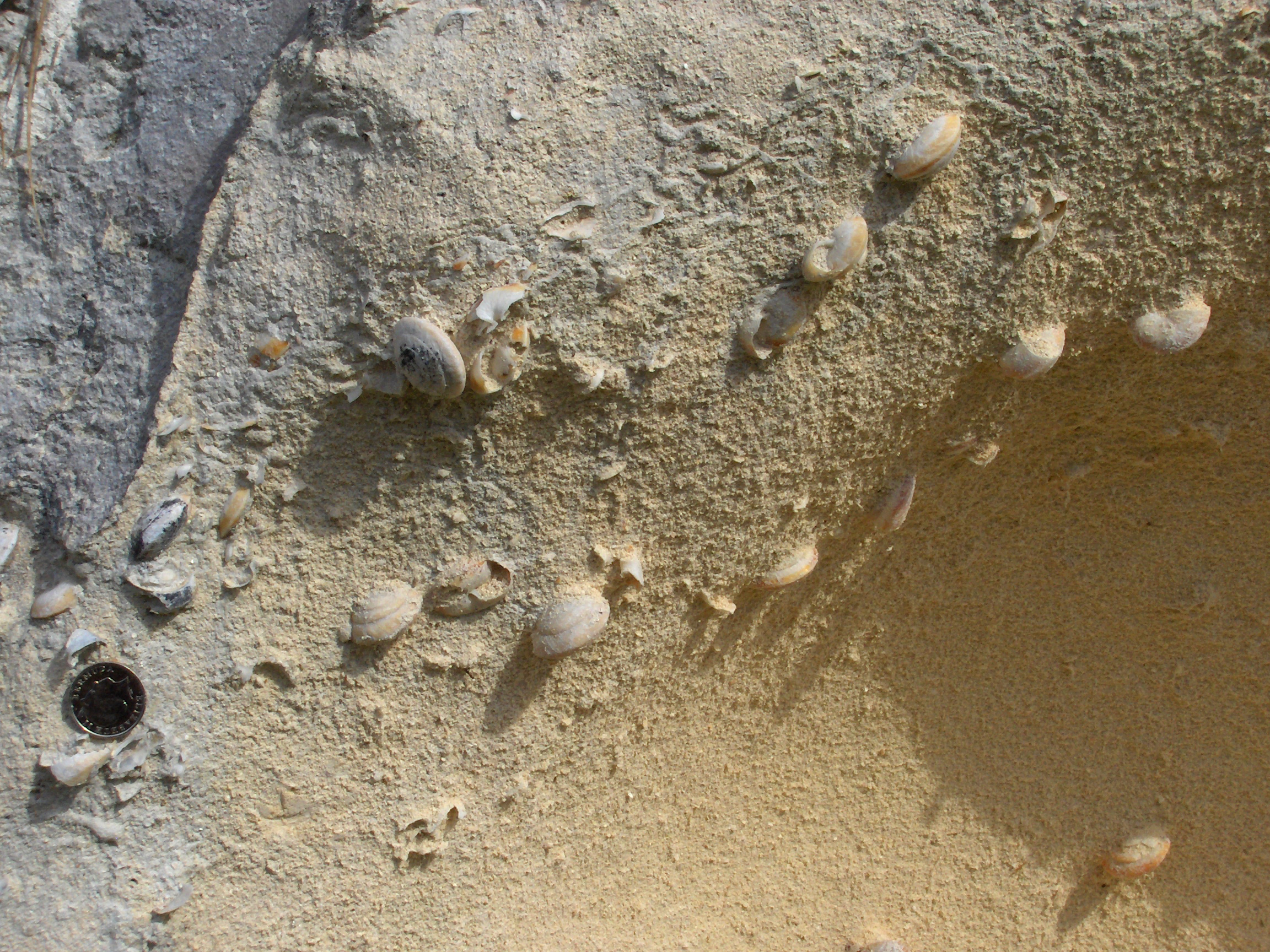
The succession of limestone deposits in Blackwatch Pass were interpreted by Bretz (1960) and Land et al. (1967) (BR1,LA2) as eolian dunes eroded at a prominent truncation surface by a rising sea level which subsequently deposited beach strata above +10m RSL. Hearty et al. (1999) (HE3) argued that this surface and overlying strata were produced by storm-wave run-up during a late MIS 5e sea level surge. However, Vacher et al. (1995) (VA3) asserted that all strata on the north shore, in the central parishes of Bermuda including Blackwatch Pass, are aeolian i.e wind blown. This interpretation was supported by Kindler and Strasser (2000) (KI1) who attributed the formation of beach-like strata to climbing ripples which typically form on the windward face (stoss slope) of dunes.
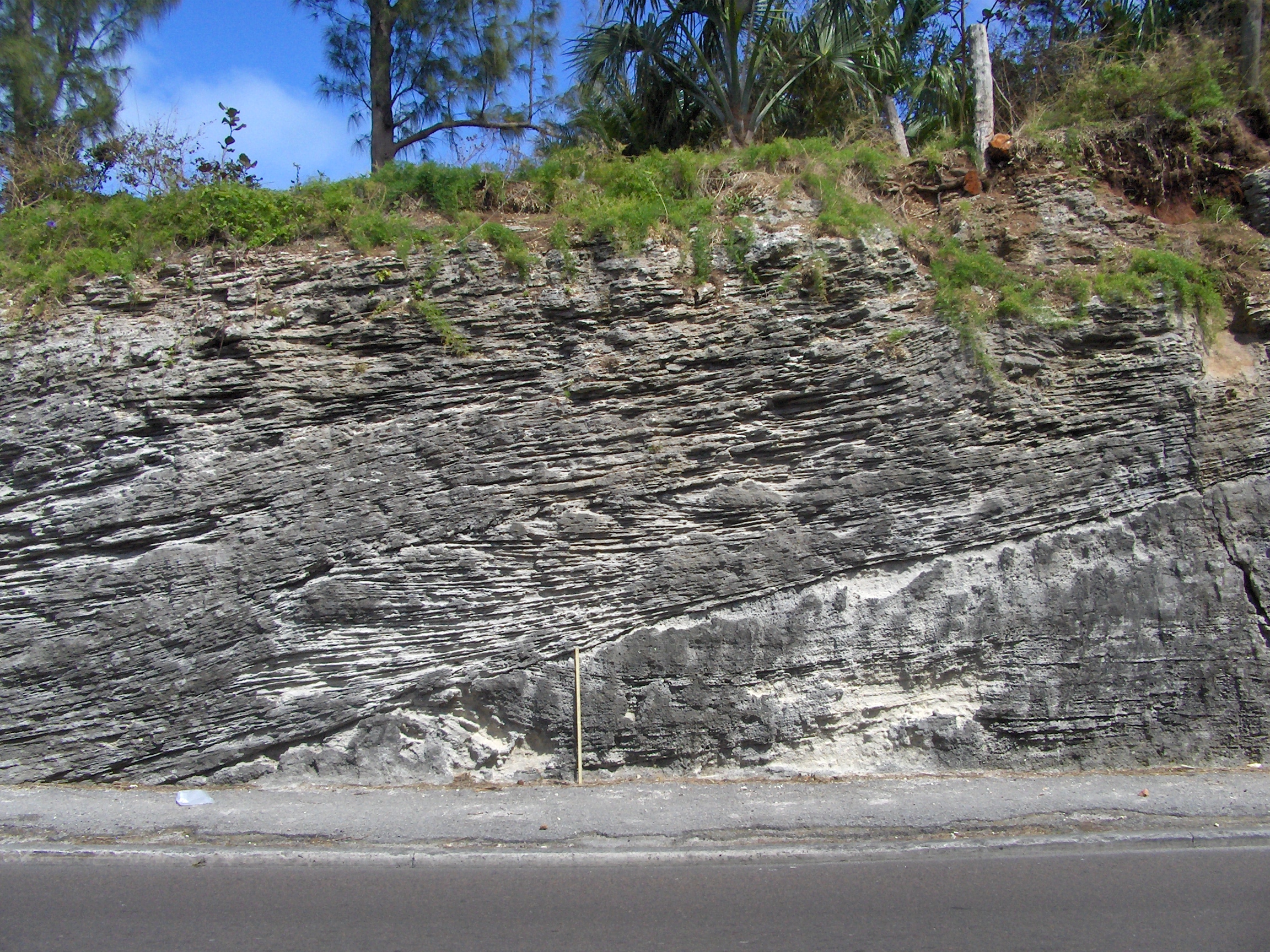
It is argued, here, that emergent water-lain marine deposits do not exist at Blackwatch Pass. No sedimentary structures diagnostic of wave action in the shoreface or foreshore environment are evident. The prominent erosion surface, which has been the subject of debate, can be explained as a deflation surface, perhaps related to a storm event. The pattern of cross-stratification is consistent with that exhibited in wind-blown dunes, or eolianites, elsewhere in Bermuda.
