
Limestone Formations and the Geological Map of Bermuda
Geologists have divided the world’s bedrock into “formations” based on differences in their physical characteristics, or lithology. The distribution and extent of these formations have been delineated on geological maps.
The Geological Map of Bermuda (Figure 5a) was the product of a Bermuda Government sponsored research project that spanned several years in the 1980s (VA6). It involved visiting (on foot or by boat) every accessible natural and man-made “exposure” of rock on the islands and making note of the lithology and orientation of the strata at each locality.
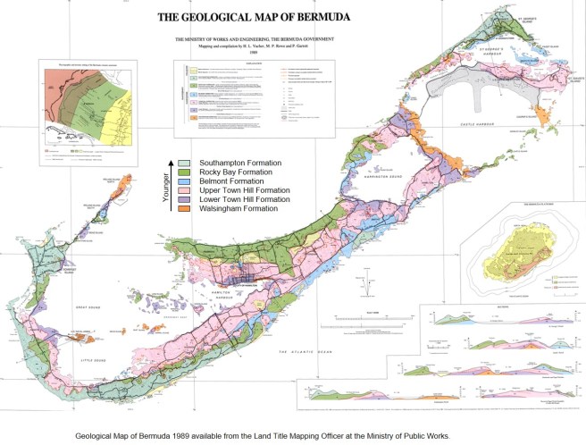
Building on earlier seminal research in Bermuda (SA1, BR1, LA2, HA1, VA1), the authors of the geological map divided the islands’ limestones into five formations. These formations, dominated by cemented sand dunes, or eolianites, are bounded by fossil soils, or palaeosols.
The five limestone formations in order of decreasing age are: the Walsingham, the Town Hill (lower and upper members), the Belmont, the Rocky Bay and the Southampton. They represent successive major episodes of dune building on Bermuda. Variations in the physical character, or lithology, of these formations are primarily age related. There is a gradation of physical and chemical alteration, or diagenesis (see below), from the youngest to the oldest limestones.
While the youngest of Bermuda’s formations can be readily distinguished from the oldest, it is often difficult to distinguish formations that are closer in age. This is why tracing of the palaeosols, which separate the formations, was fundamental to the mapping project. Technically, this is known as an allostratigraphic approach to mapping.
Ages that have been attributed to the formations are somewhat tentative, particularly with respect to the older formations. This is because there is no direct method of determining an absolute age of pure sedimentary limestone. For some formations there is a marine member in addition to the volumetrically dominant eolianite member. Reliable ages have in these cases been determined from u-series radiometric dating of fossil coral fragments found in the marine member (Chapter 9).
Relative, rather than absolute, age determination using a techniqe known as amino acid racemization (AAR) has proved useful when applied to fossil landsnails which are found in weak intra-formational palaeosols, or protosols. When the dune ridges are not in contact with each other and where one or both are not correlated with a dateable marine deposit, this technique can help to resolve their stratigraphical relationship i.e. which geological formation they, respectively, belong to (HE3,HE6).
Approximate formation ages in thousands of years (ka) which have been attributed through dating of corals are: Southampton Formation – 80 ka (VA2,HA1,LU1,MU4); Rocky Bay Formation – 120 ka (LA1,VA2,HA1,MU4); Belmont Formation – 200 ka (HA1,HE2,MU4,RO4). Formations whose ages have been estimated by other means, such as dating of cave deposit, or speleothems – are: Lower Town Hill Formation – 300 ka (HE2); Upper Town Hill Formation – 400 ka (HE2); and Walsingham Formaton – ≥700 ka (HE2) .
Diagenesis
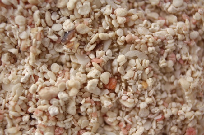
Bermuda’s limestone formations all started out the same – as deposits of loose, mostly wind-blown, carbonate sand of marine origin. Over time, the ageing process, known as diagenesis, altered their chemical and physical characteristics. The youngest formations, having undergone the least amount of alteration, resemble weakly consolidated beach sand (Figire 5b). While in the oldest formations the corroded remnants of sand grains are difficult to distinguish and are fused together by cement (Figure 5d).
The principal agent of diagenetic change that has acted on Bermuda’s limestones is rain water. As it penetrates, or percolates, through the surface-soil this water becomes weakly acidic. Carbonate sand grains comprising the skeletal remains of marine organisms composed of unstable of High-Mg (Magnesium) calcite and Aragonite (a form of calcium carbonate) are altered or dissolved. These dissolved minerals are then re-deposited, or precipitated, in the pores of the limestone as stable Low-Mg calcite cement.
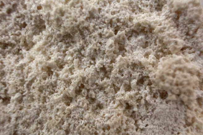
On Bermuda, the youngest and therefore least altered and least cemented limestones belong to the Southampton Formation. Older limestones of the Rocky Bay and Belmont Formations are better cemented but still retain a primary granular texture, similar to beach sand (Figure 5b). Increasingly, in the Upper and Lower members of the Town Hill Formation (Figure 5c) and then the Walsingham Fomation (Figure 5d), the grains become corroded and more tightly cemented.
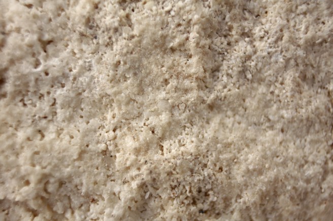
Land, Mackenzie and Gould (LA2) proposed a system of classifying Bermuda limestones in five diagenetic grades, I to V, based on changes in relative proportions of the following: 1. High-Mg Calcite, 2. Aragonite (a form of calcium carbonate), 3. Porosity and 4. Low-Mg calcite cement. They present a chart showing how the last of these, namely calcite cement, increases over time primarily at the expense of unstable aragonite and pore space, resulting in an increase in limestone density. At one extreme is the weakly cemented, or friable, Southampton Formation and at the other is the “tenaciously indurated” Walsingham Formation.
Bermuda Limestone as a Natural Resource
Bermuda limestone is a valuable natural resource – principally as a source of building materials but also as an aquifer within which fresh ground water has accumulated. Because of a significant variation in the physical characteristics of limestone across Bermuda, as represented by the Geological Map (Figure 5a), there is an associated geographical variation in its value as a resource of one kind or another. This is a function of the amount of calcite cement that bonds the carbonate sand grains together and which is key to the limestone’s compressive strength and porosity. The youngest formation – the Southampton – being weakly cemented is a good source of sand for mixing with cement to create mortar or plaster for building purposes. Although the Rocky Bay and Belmont Formations are extensively quarried for building stone, it is the older Town Hill Formation which is preferred by masons owing to its cohesiveness. The oldest formation – the Walsingham – has historically been the source of Bermuda’s most durable building stone, as attested to by the well-preserved state of many old military buildings and forts (Figures 5e and 5f). Its density has however been a deterrent to exploitation of its full potential. The laborious process of cutting the indurated Walsingham limestone into block has now been eschewed in favour of crushing it into aggregate for road surfacing and for concrete production.
Prior to the introduction of Portland cement and concrete which are the bases of modern construction, Bermuda was adequately served with quarried limestone block, discussed above, and lime mortar. Limestone was burned in wood-fired kilns which were often built into the side of a hill to facilitate loading. The quicklime produced from the limestone fired in these kilns was added to water in containers such as barrels and soaked, or slaked, for an extended period of time. The product – slaked lime – when mixed with sand, served as a very effective mortar and plaster, if somewhat slow drying.
The historical importance of these limestone resources to Bermuda is evident from the numbers of production facilities which once existed. Arthur Johnson Savage, who completed the 1901 Ordnance Survey map of the Island, identified 237 quarries and 90 lime kilns scattered across the islands. There was no strong correlation with geology, but the highest density of quarries was in the Town Hill Formation, while that of kilns was in the Rocky Bay Formation.
The value of Bermuda limestone as a ground water aquifer is dependent on the inter-granular porosity (porosity between the grains) and permeability. To be capable of storing rain water, porosity must be high and the permeability must be low, as in the youngest formations. When the pore spaces of older limestones fill with cement, secondary channels are opened up by ground water flow, a process which causes a large increase in permeability, and ultimately creates caves. The oldest limestones, with their high permeability, are therefore susceptible to sea water intrusion and are for the most part occupied by saline ground water. It is the youngest formations, particularly the volumetrically dominant Rocky Bay Formation, within which the nucleii of significant “fresh” ground water bodies, known as “lenses”, have formed (VA5). The four main lenses which have accumulated in this way and have been exploited for public water supply are the Somerset Lens, the Port Royal Lens, the Central Lens (of Pembroke and Devonshire) and the St. George’s Lens (Figure 5g). At its peak, sustainable abstraction of low salinity ground water for public water supply exceeded 1 million Imperial gallons per day.
Another feature of Bermuda limestone which qualifies it as a resource, is the network of spectacular caves which it contains. These caves are valuable as subjects of biological and climate research, as recreational spaces and as tourist attractions. Their density, which is highest around the perimeter of Harrington Sound, is a function of limestone age (Chapter 7). The majority of accessible caves occur in the oldest limestone formation, namely the Walsingham.
