
Types of Fossil Soils
Fossil soils, or palaeosols, are thin undulating layers of sandy clay that run through Bermuda’s limestones and, in some cases, separate the geological formations (Chapter 5). They originally formed as surface soils on ancient landscapes where plants and trees grew. They are preserved today because they were buried by advancing sand dunes which eventually became cemented into limestone rock, known as eolianite (Chapter 3).

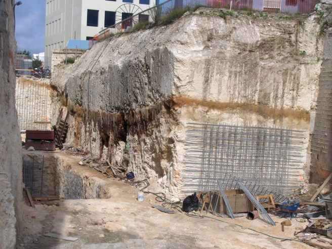
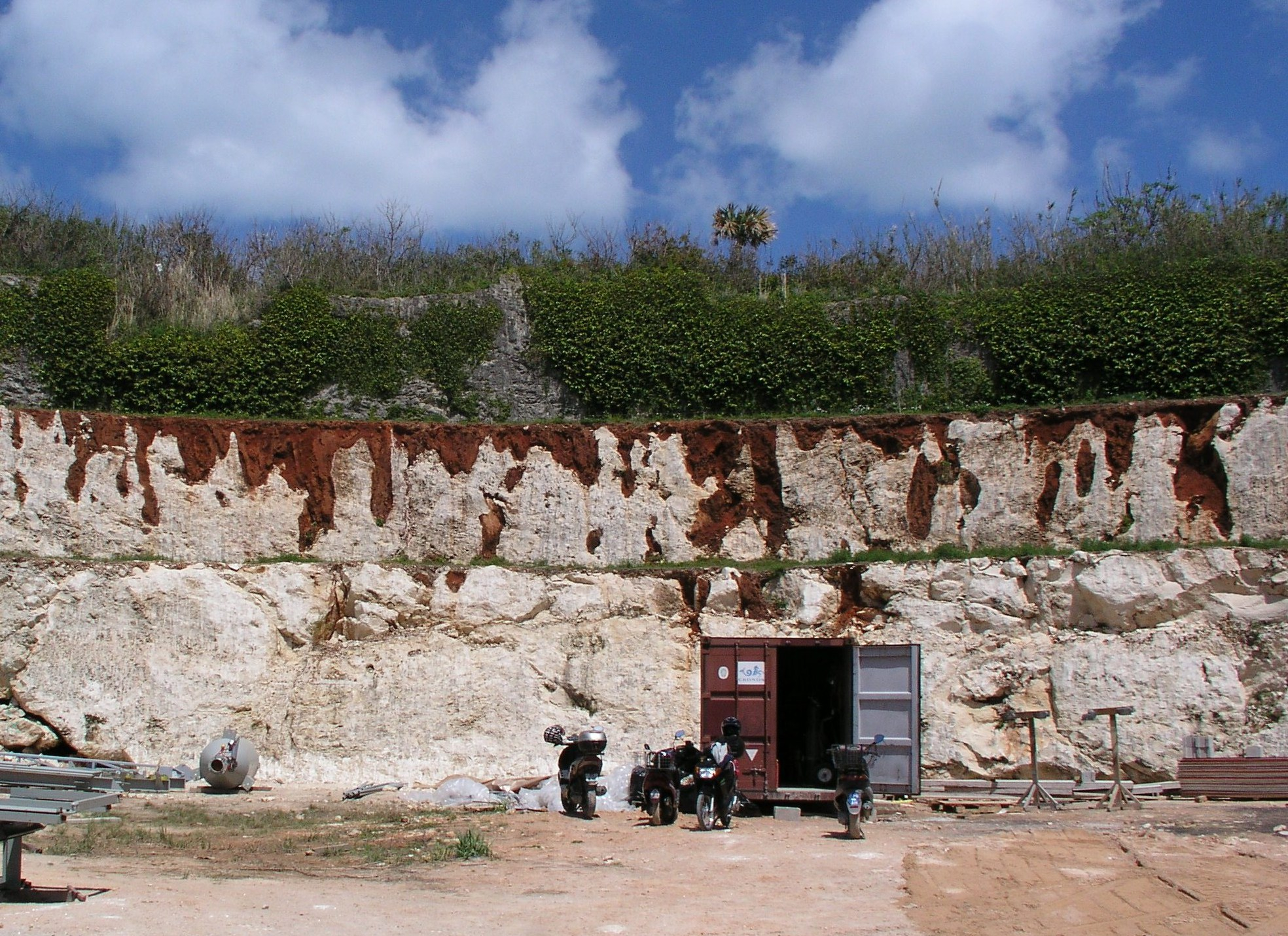
The best developed palaeosols accumulated in valleys or on sheltered hillsides over periods spanning tens, or hundreds, of thousands of years. They tend to have a reddish brown colour (Figures 6b, 6c and 6d) attributable to high content of iron rich clay. These are classified as terra rossa palaeosols and typically range in thickness from 0.25 to 0.5 m (1 to 1.5 ft).


Terra rossa palaeosols represent significant time boundaries. They developed across the present islands as well as the now submerged Bermuda platform during glacial periods when sea levels were much lower than at present (Figure 1f, Chapter 1). Exploratory drilling through the seabed of the Bermuda platform has confirmed the presence of these palaeosols, submerged and entombed within limestone sediments (V03). Forestation of the platform in quite recent times is corroborated by the discovery of submerged stumps of cedar trees found in Mills Creek, at Gurnet Rock and in the St George’s Town Cut. The genesis of terra rossa palaeosols will be discussed in more detail later in this chapter (below).
A second category of palaeosol found on Bermuda are the “protosols”. These soils are light coloured, varying from white (Figure 6e) to light brown (Figures 6f and 6g) to pinkish (Figure 6h), and would have accumulated over relatively short periods of perhaps no more than a few thousand years. Their thickness is typically about 0.5 m, but can range up to 2 m (6 ft) or beyond (see Photo 6 in the Photo Gallery). They are constituted of a high proportion of wind blown sand and often include well preserved fossil land snails (Poecilozonites). These features of protosols reflect the trapping of aeolian sand in a vegetated terrain on temporarily stabilised dunes. Unlike terra rossa palaeosols, they do not represent significant time boundaries in the geological record.


The genesis of terra rossa soils
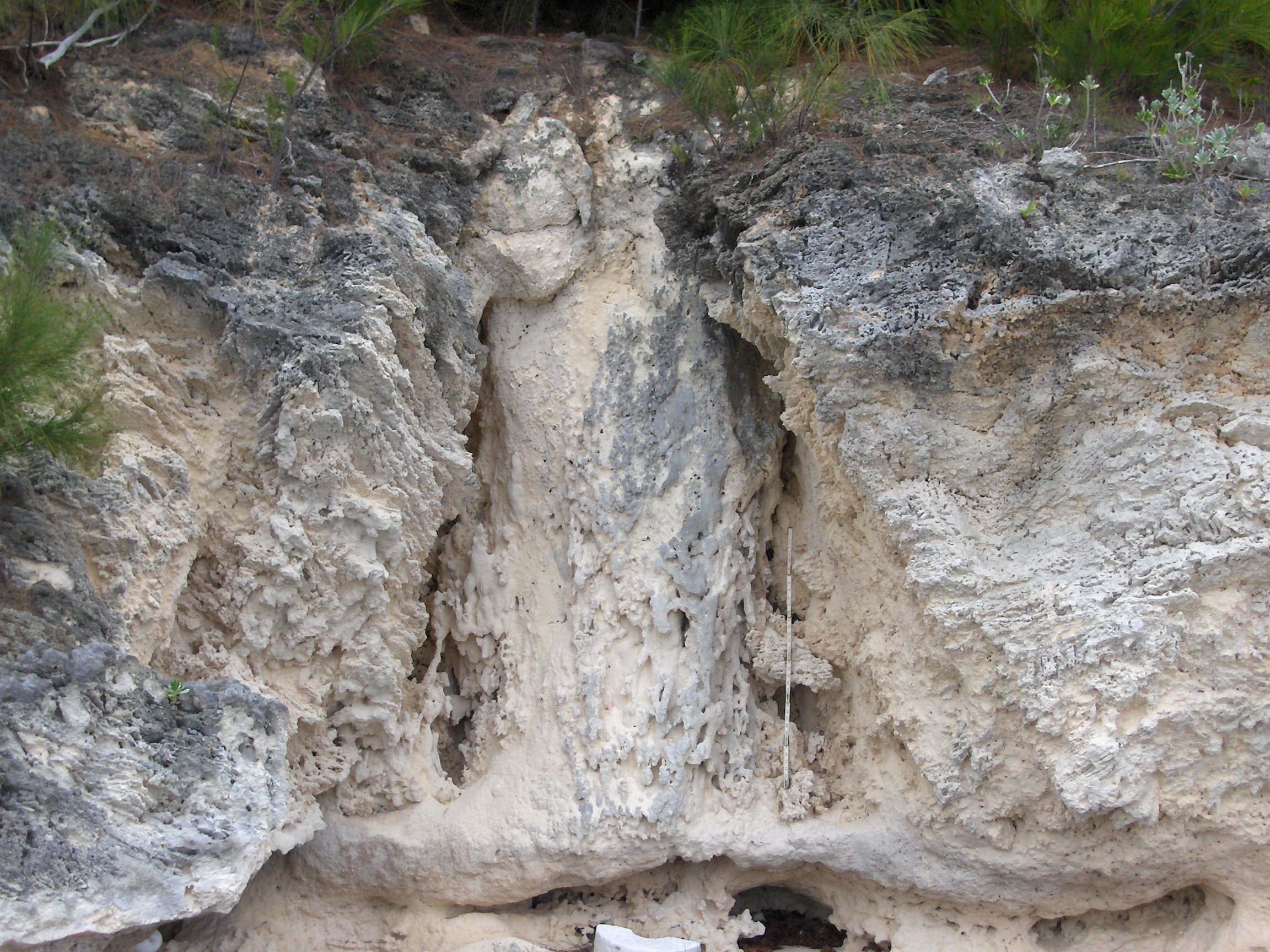
The best developed soils in a limestone terrain are terra rossa soils. They occur as surface soils (Figure 6i) and also as buried fossil soils, in which case they are known as terra rossa palaeosols (Figures 6b, 6c, 6d, 6j) . Their reddish brown hue is attributable to non-carbonate particles (including iron oxides) which are otherwise a rarity on limestone islands such as Bermuda.


As a terra rossa soil forms, the underlying limestone surface is simultaneously being dissolved and lowered by the chemical action of acidic water within the soil. The dark clay material within the terra rossa soils was once considered to be exclusively the residue of non-soluble impurities within the limestone, which were concentrated in the soil as the limestone was dissolved (SA1). However, because of the high purity of Bermuda’s limestones it has been calculated (LA2) that the thickness of limestone that would have to be dissolved to produce sufficient insoluble residue to form a typical Bermuda terra rossa palaeosol is unrealistically large. Other sources of the non-carbonate minerals within these palaeosols, and soils, therefore has to be found.
There is evidence that “foreign” minerals found in Bermuda’s soils arrived as airborne dust which was carried from the Sahara Desert by winds which circulate high in the atmosphere. These air currents flow westward near the equator and then northward, across the Caribbean and North America, towards Bermuda. The chemistry of the particles appears to support this hypothesis (HE12).
An alternative explanation for the composition of these “red” soils is that the non-carbonate minerals, including silica, are actually not so foreign, and largely comprise material that was derived locally from the Bermuda volcanic seamount (PR1). When sea levels were low, during glacial periods of the Pleistocene Epoch, the edge of the Bermuda platform would have been exposed to wave erosion. Resultant beaches of volcanic sand would, it is argued, have provided a source of iron-rich (red) material to be carried landward by the wind and accumulate on the land surface as a component of the soil.
Soil pipes or “palmetto stumps” – which?
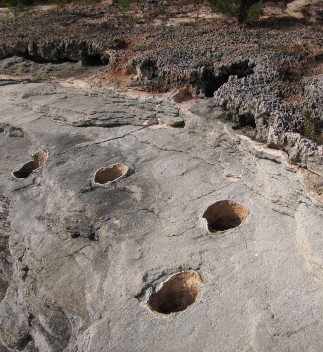
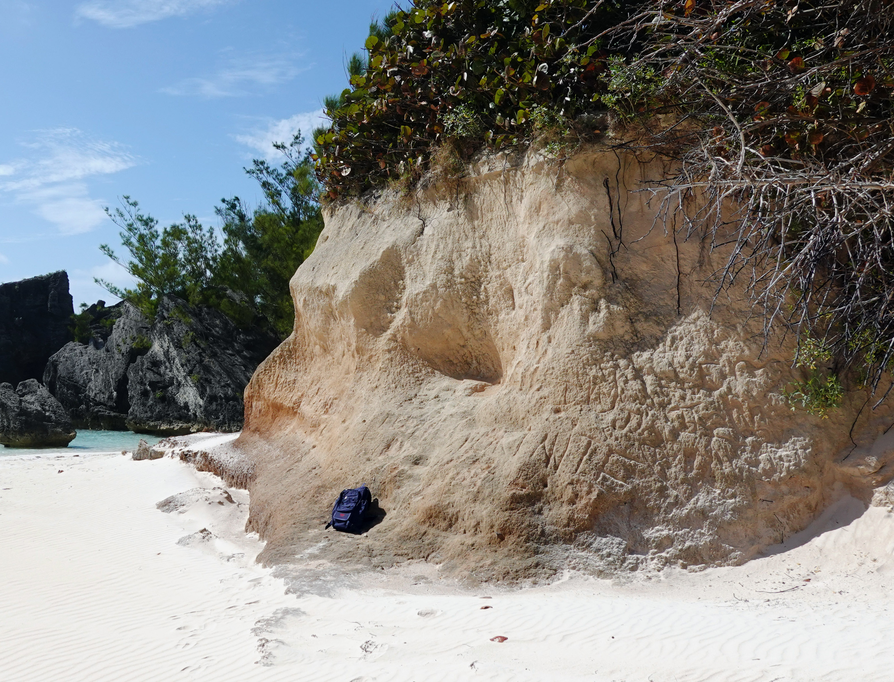
Mature terra rossa soils, or palaeosols, often have an irregular contact with the underlying rock (Figure 6i), representing uneven dissolution of limestone by acidic soil-water. Where this surface, or contact, is deeply pitted it is known as “karst” of which “dissolution pipes” or “soil pipes” are a subset. They are tubular or conical soil-filled structures which can penetrate multiple metres into the limestone bedrock.
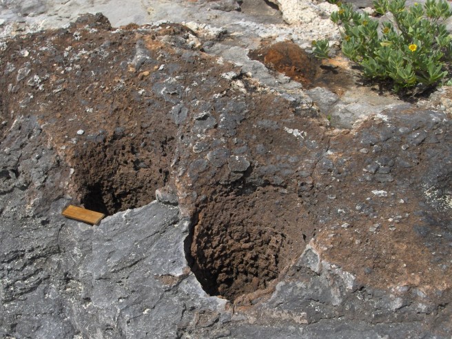
Soil-lined pipes or conical hollows are found in abundance along Bermuda’s rocky shorelines (Figures 6k and 6l). They are described in 19th and early 20th century accounts of Bermuda’s geology, at which time there was no consensus on their origin – and so commenced a long-running debate.
Nelson (1837) (NE1) proposed that these hollows in the limestone were the product of root growth or the action of water. Verrill (1907) (VE1), on the other hand, named the soil filled circular structures “palmetto stumps” – a term that persists in Bermuda’s geological vernacular today. He envisaged the partial burial of palmetto trees by accumulations of sand. Following their death and decay, he argued that each tree left a cylindrical void in the hardening limestone which subsequently became filled with soil.
Sayles (1931) did not agree with Verrill’s assertion that trees were directly involved, stating that “….these “palmetto stumps” are nothing but solution holes caused in the development of soils”. Some people have continued to favour Verrill’s explanation, but the consensus among geologists who have studied these features in recent decades is that they are indeed solution holes, commonly known as “soil pipes”. This conclusion is supported by the close relationship, which invariably exists, between the soil pipes and an overlying terra rossa soil, or the remnants of one (Figures 6i, 6l, 6n). Only where this soil has been stripped away (Figure 6k), and the top of the soil pipes exposed, can the false impression be given that these features might have extended upwards through the limestone and represent the position of ancient buried tree trunks.


Processes that might initiate the development of solution holes or “pipes” at the base of soils include the concentration of rain water flow (“stemflow”) into the ground around tree trunks (HE11, HE13) and the growth of tap roots (BR1). Either of these, or a combination, amount to the same explanation proposed by Nelson in 1837 (NE1)
There is no question that palmettos and cedar trees were buried by advancing dunes. Evidence is seen in the form of structureless pillars, or columns, of sand found within ancient cemented dunes, which are the casts of former tree trunks (Figure 6p and Figure 9j, Chapter 9). They are preserved within the limestone strata, often extending upwards from fossil soils in which the trees once grew (Figure 6p) . The sand columns are white, however, and cannot be confused with reddish-brown soil-filled putative “palmetto stumps”.
There are many instances, observed in the field, of soil-filled pipes, cones or pits which extend downwards from a terra rossa soil, or palaeosol, as illustrated in Figure 6o. These occurrences corroborate the “dissolution pipe” hypothesis. In contrast, there is no documented example of a red soil-filled pipe which extends upwards from a palaeosol, as would be expected had any originated as “palmetto stumps”.
