
The accumulation of sediment on the Bermuda platform
The skeletal remains of marine lifeforms – corals, molluscs, algae, forams, echinoderms etc – which live and die on the Bermuda platform are ultimately broken down, or comminuted, into small fragments, by biological activity and wave erosion. Over millions of years, vast quantities of carbonate sediment have thus accumulated on the platform and spilled onto the flanks of the seamount. Ultimately, a portion of this sediment has been driven onto beaches and thence onto the land by wave action and by the wind.
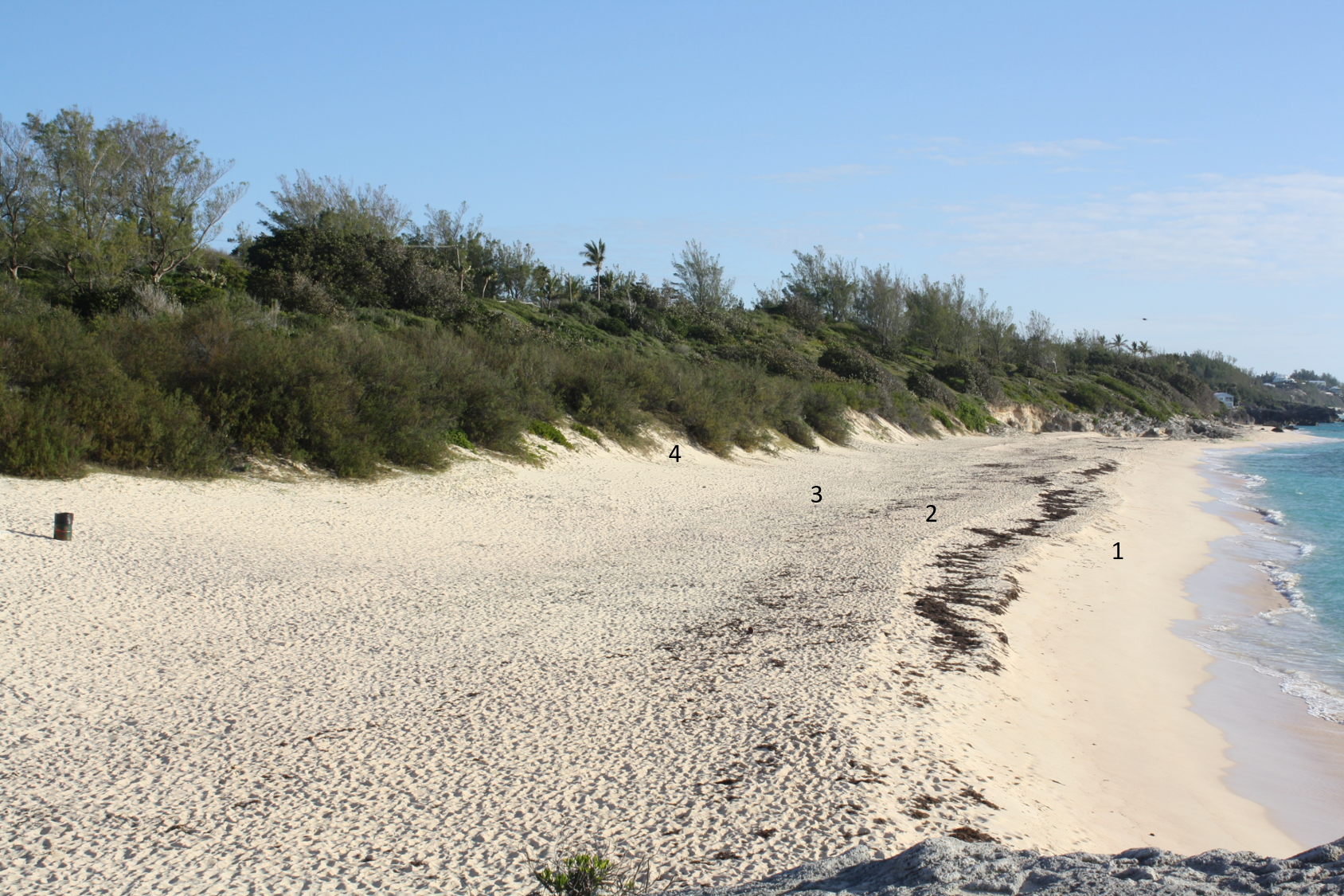
Beaches are unstable features which typically receive sand from the Photo Gallery in fair weather and give it up to the sea during storms. They are the source of wind-blown sand that is trapped in vegetation to form coastal dunes. Present-day beaches and dunes of Bermuda are of limited extent, relative to the length of rocky coastline. The beaches, which can be categorised as reflective, are narrow and vulnerable to erosion; while the dunes are small, vegetated and inactive (Figure 3a). This contrasts with conditions which prevailed on many occasions in the past.
The sand dunes that built Bermuda
An ample supply of un-stabilised sand and moderate to strong winds are prerequisites for the construction of large sand dunes. Notable environments where these conditions can exist are deserts (Figure 3b) and sandy coastlines (Figure 3c).


As early as 1837 Lieutenant Richard Nelson of the Royal Navy (NE1) established that the Bermuda islands are constructed principally of hardened wind-blown sand dunes. Later, in 1931 American geologist Robert Sayles coined the now widely-used term “eolianite” based on his observations in Bermuda (SA1). He defined eolianite as cemented carbonate sand which originally accumulated by action of the wind. .
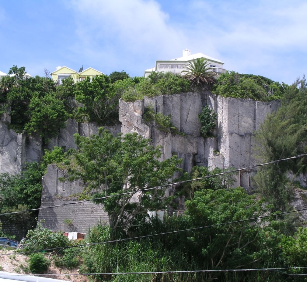
The dunes that formed the limestone hills of Bermuda, although of a coastal variety, extended inland well beyond the immediate vicinity of the beach. Their size (Figure 3d) and mobility were quite unlike anything observed in present-day Bermuda. Multiple dune formations attest to numerous occasions in the geological past when a large supply of sand was accessible to the wind, on beaches of a width which exceeded the “critical fetch” (MO1). This is the minimum width of dry beach that wind must travel across in order to gather up, or entrain, sufficient sand for the growth of coastal dunes.
The fluctuation of sea levels associated with the cyclical advance and retreat of the continental ice sheets, particularly over the last one million years or so, were critical to dune building on Bermuda. The changing sea levels presented multiple windows of opportunity for the development of wide wind-swept, dissapative, beaches along significant lengths of Bermuda’ coastline. It was at these times that new ridges of dunes would have been appended to the increasingly hilly islands (RO3).
Sand dune activity on Bermuda during the 19th Century
Compared to sand dune activity of the geological past that built Bermuda, dune activity since the settlement of the islands has been of limited extent. Nonetheless episodes of heightened dune activity have been recorded in historical times.
In 1835 Bishop Inglis a visitor from Canada documented (in a letter archived at the National Museum of Bermuda) burial of houses by the accumulation of sand up to 12 feet deep in Tucker’s Town. He recounted meeting a man who “… showed us the ruins of the house in which he was born … and which is now covered to the depth of 8 feet (of sand), but the lines of the walls, and the chimney, are still visible”. At Elbow Beach in 1837, Lieutenant Nelson reported a sand dune which “supported by constant supplies (of sand) from the sea, has steadily climbed up the hill to the very summit, a height of 180ft.” (Figure 3e). He observed that “…. the dazzling dry, and almost snow-white sand is checked, before the front of the trees, in a steep bank, varying from 10 to 25 feet in height.” and “As soon as the mass shall have over-topped the woods, I know nothing capable of opposing its progress.”.

Some sand dunes were still active when visited, as an object of scientific curiousity, by British scientists of the Challenger expedition in 1873 (Figure 3f). Later still in 1889, Angelo Heilprin (HE9) observed active dunes at Elbow Beach and Tuckers Town which he described as “great tongues of sand” and “sand glaciers…stealthily encroaching on hilltops of the interior and burying everything” including houses (Figure 3g) at both locations.


Figures 3f and 3g. (Click on images to enlarge).
Dune activity apparently dwindled through the early 1900s to the point that in 1931 Sayles (SA1) declared an absence of active dune-building on Bermuda. In making this observation, he surmised that conditions quite unlike those of recent times were required to trigger a meaningful dune building event. He was the first to make the association between dune activity and sea level fluctuations of the Pleistocene Ice Ages.
Although of limited significance in terms of an impact on the geological record, the cause of historical bouts of dune activity could be of relevance to our understanding of more prolific events of the distant past. It had been suggested, for example, that 19th century dune activity on Bermuda was triggered by “clearing of brush” during construction of coastal fortifications (VE1). Similarly, Robert Sayles (SA1) and Stanley Herwitz (HE10) advocated a connection between heightened dune activity and climate-related degradation of vegetation-cover. However, they failed to account for fossil evidence of flourishing plant life, such as a proliferation of herbivorous land snails and palmetto leaf impression, preserved within the dunes. Sayles (SA1) did to his credit recognise that, regardless of the magnitude of any botanical effect, a key prerequisite for the episodic generation of massive landward advancing dunes was the delivery of an abundant supply of sand via expansive beaches. The cause and timing of such surges in sand supply during Bermuda’s geological history is discussed at the end of this chapter.
Stratification of Bermuda’s limestone dunes
Sedimentary rocks are the dominant rock type on the surface of our planet and thicknesses typically exceed 1 kilometre. They are formed by the accumulation of layers of loose sediments which through the effects of time became consolidated or “lithified”. These ancient lithified sediments can be classified on the basis of their chemical composition, structure and particle size, which can range from that of clay or silt, through sand to pebbles and cobbles. When sedimentary rocks are exposed in a rock face, small differences in colour, cementation or in the size of particles between one layer and the next are manifested as bands known as “strata”. Such strata can range from less than one millimetre to several metres (yards) in thickness.
The majority of sedimentary rocks were deposited on deep sea-beds or lake-floors in horizontal layers (of mud, silt or sand) but subsequently may have been tilted and folded by tectonic forces. In some depositional environments, however, the sediment did not simply settle in layers, but was transported along by water currents or by the wind. Rivers, shallow seas, sandy shores and deserts are examples of such environments.
A sediment surface which is exposed to a strong current is sculpted into moving bedforms, such as ripples or dunes. The accumulation of cascading sediment on the downstream side of these features represents lateral growth, or lateral accretion. This creates series of sediment layers which slope down in the direction of the current or wind flow. When, and if, they are preserved in rock, they are termed “cross-stratification” (Figure 3h and 3i) to distinguish them from originally flat stratified deposits which simply accumulated by settlement of sediment.
Cross-stratified deposits typically feature intersections of sets of strata at “bounding surfaces” across which there can be a marked change in the orientation of the strata (Figures 3h and 3i). These bounding surfaces represent transitions between phases of accumulation and phases of erosion – reflecting changes in: wind/current direction, sediment supply and, in the case of aeolian dunes, vegetation cover.

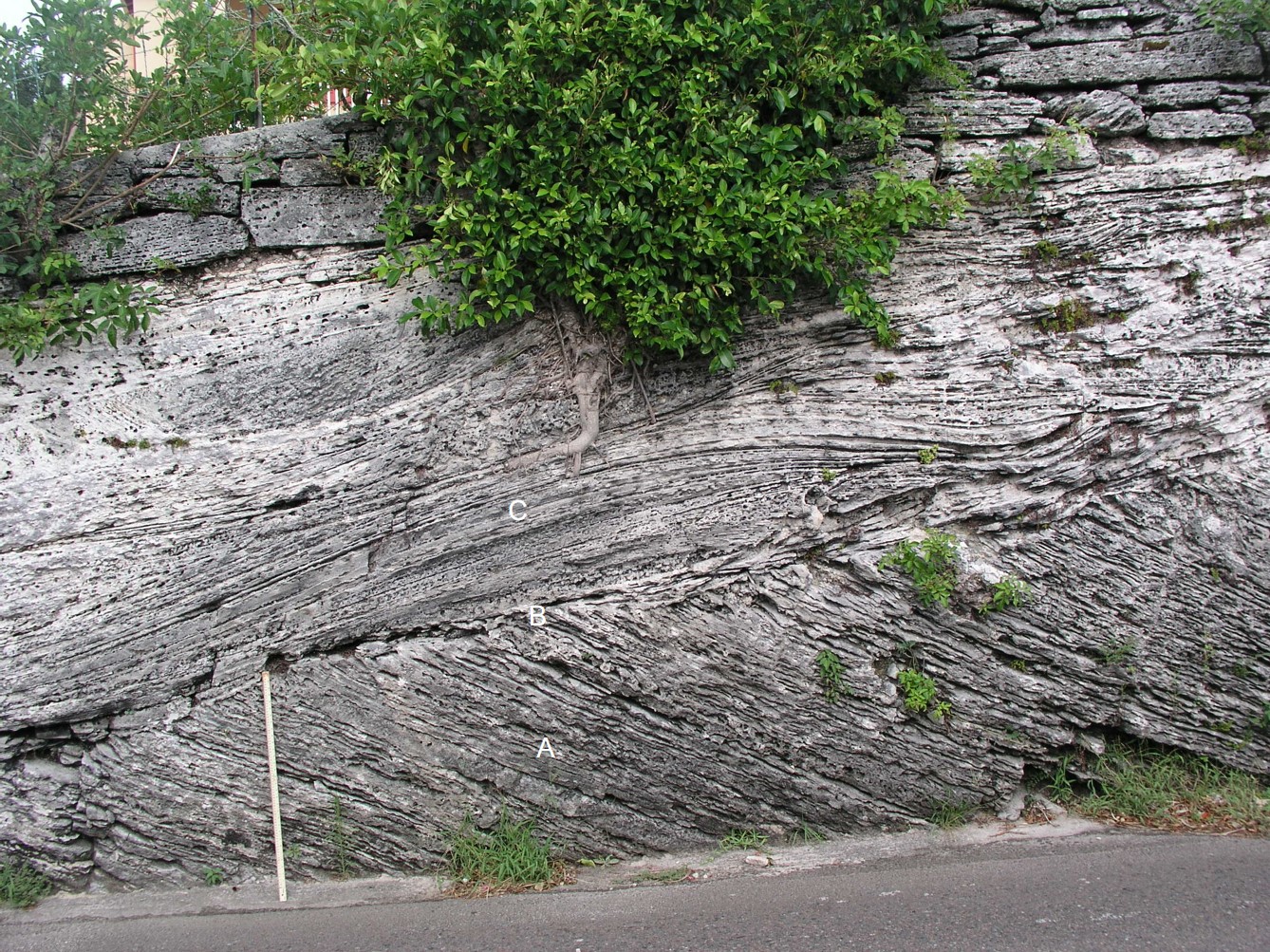

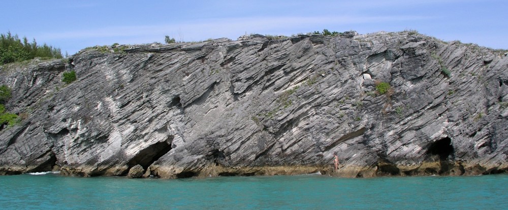
A particular dune geometry, consisting of low angle strata which feeds into or over-rides and truncates steeply sloping slip-face cross-strata (Figure 3i), is displayed in rock faces and cliffs throughout Bermuda. Variations in the proportions of these two types of strata – low angle and high angle – are attributable to a dune’s behaviour, which can range from a static structure which stores sand to a mobile structure which transports sand. (Figure 3k). In noting “the establishment of a slip face has a profound effect on the subsequent life history of the dune” Ralph Bagnold (BA1), a pioneer in sand-dune science, enunciated a fundamental relationship between dune form and dune behaviour – that the existence of a slip-face is diagnostic of dune mobility.
In their simplest form, mobile sand dunes are wedge shaped structures. There is a gently sloping windward face, up which sand is blown from the general direction of the sand source, such as a beach. At the top end of this slope there is a brink over which sand cascades onto the steep leeward face of the dune, or “slip-face”. The slope, or dip, of this face – approximately 30 degrees to horizontal – is determined by the “angle of repose” of dry sand.

Characteristics of Bermuda’s limestone dunes
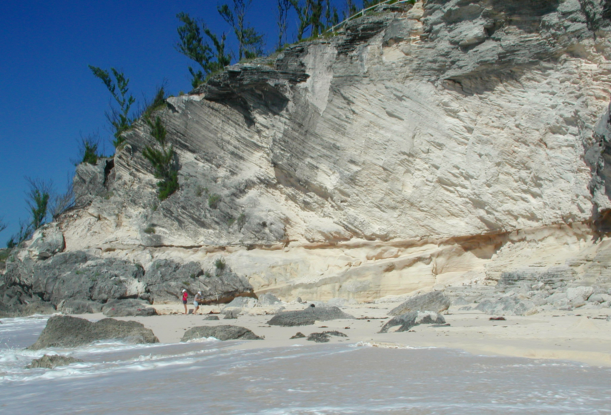
As noted above, the geometry of sedimentary strata is indicative of environmental conditions, such as current/wind strength and sediment supply, at the time of deposition. The high proportion of slip-face cross-strata, or foresets, present in Bermuda’s eolianites (Figures 3l and 3m) demonstrates significant transfer of sand from the windward face and dune-top to the leeward face; and is diagnostic of dunes – in this case coastal dunes – which have become unstable and mobile. Such dunes, which transport sand laterally, are known as “advancing dunes” (MA3, RO2). Their existence reflects the inability of vegetation to stabilise wind-blown sand, which likely coincided with episodes of high sand supply.
It can be concluded, that the dunes which formed the hilly topography of the Bermuda islands were not static mounds of sand, fixed in position by vegetation, or by rapid cementation as had once been asserted (BR1, LA2). It is evident that they were mobile structures which advanced, or migrated, landward from the beaches and up onto the bordering hillsides burying plants, including tall trees, in their path (RO2) (See Chapter 9).
An illustration of typical Bermuda dune types, their stratification and their evolution can found here.
The arrangement of Bermuda’s sand dunes
Bermuda’s earliest limestone deposits would have co-existed with remnants of the volcanic island. Evidence for this exists in the form of isolated deposits of volcanic sands (at Whalebone Bay) and volcanic pebbles (at Government Quarry and Stokes Point) inter-layered or mixed with the dominant carbonate sediments. The oldest islands of Bermuda, including remnants of the volcanic island served as nuclei for the accumulation of later limestone deposits. Beaches which formed around the edges of pre-existing islands intermittently provided sources of sand for large wind-blown dunes. Some of the oldest dunes of the Walsingham Formation (e.g. at Government Quarry, Hamilton Parish), although overwhelmingly constituted of calcium carbonate sand, include black or rust-coloured flecks representing the occasional grain of volcanic origin.
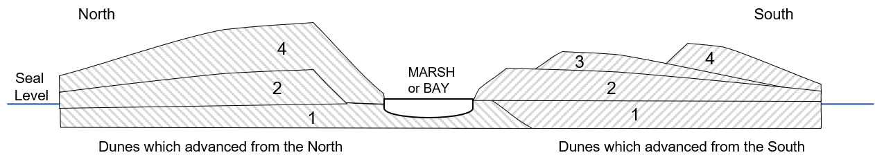
Bermuda’s dunes began life as sand mounds, or foredunes, which formed amongst vegetation at the back of beaches (Figure 3a). During episodes of plentiful sediment supply they grew into, or were entombed by, much larger and more mobile desert-like dunes. These dunes coalesced into linear ridges at the back of extensive beaches, the likes of which do not exist today. Their structural resemblance to transverse dunes of the Oregon coast (Figure 3c) was noted by Fred Mackenzie (MA1). One ancient dune ridge, of the Rocky Bay Formation, now occupies the entire length of the North Shore in the central parishes (See Geological Map, Figure 5a, Chapter 5) . At the time of formation this would have been associated with a beach approximately 5 km (3 miles) in length situated to seaward of the present north shore. The absence of a preserved beach inlcuding datable coral fragments means that an absoulte age for this dune ridge has not been directly determined. However a measure of the relative age of fossil landsnails by amino acid racemization (AAR) has inferred that it is the same age as the Rocky Bay dunes on the South Shore, i.e. around 120,000 years, which associates its construction with the last interglacial period (VA3).
Present climatic conditions at Bermuda produce south-westerly prevailing winds and westerly gale force winds. Had these same conditions existed in the past, as is likely, then one might have expected ancient wind-blown dunes to have advanced in a generally east-north-easterly direction. However, the orientation of their leeward slip-faces indicate that Bermuda’s dunes advanced predominantly in an inland direction (Figure 3n). Those on the north shore advanced south, those on the west shore advanced east and those on the south shore advanced north. (East-facing shores are very limited in length).
An analysis of over 3750 slip-face orientation measurements taken from Bermuda’s Pleistocene dunes was undertaken to determine the relationship between the direction of dune migration and the wind regime (RO2). A summary of the results in map-form can be found here. It is apparent from these data that, regardless of their frequency, onshore winds were more effective at dune building than prevailing or gale force winds. This may be attributable to the relatively high capacity of non-turbulent wind, which blows directly off the sea, to transport sand landward having crossed a beach-source (RO2), as compared to turbulent wind which has traversed Bermuda’s hilly topography. In any case, the record shows a tendency for dunes on all shorelines to advance inland away from the coast, climbing onto the flanks, and often over the top, of their predecessors (Figure 3o). The pattern of accumulation is reflected in the arrangement of the geological formations and in the topography of the islands, which rise up to ~80 m or 260 ft above mean sea level.

The debate over the timing of dune-building
Robert Sayles (1931) attributed the initiation of dune building on Bermuda to harsh climatic conditions and falling sea levels at the onset of glacial periods during the Pleistocene Epoch. He advocated an asssociation between maximum dune activity and a lowered sea level, which stood approximatrly 20 metres or more below its current position; thus exposing the seabed on the Bermuda platform. He depicted “great flats covered by marine shells exposed to the air” which were caused “to pile up as dunes” (SA1).
J. Harlen Bretz (1960), rejected Sayles’ interpretation. Based largely on his observation of supposed beach-dune transitions above present sea level, notably on the North Shore at Blackwatch Pass and Whalebone Bay, he asserted that major dune building activity coincided with sea level rising to a peak, following a small oscillation (BR1).
Leonard Vacher (VA1) generally agreed with the conclusion of Bretz with respect to North Shore dune deposits, but argued that South Shore dune activity was not similarly “forced” by a rising sea level nor, for that matter, a falling sea level (VA3). It was instead the outcome of stable warm conditions at the peak of an interglacial period when sediments being generated in the “carbonate factory” on the south shore ledges would eventually fill “accommodation space”. He postulated (VA1) that, at this point, the carbonate sand would have spilled shoreward onto widening wind-swept beaches and, thence, into large dunes.
The historic debate, briefly summarised above, as to whether dune-building on Bermuda occurred at high sea levels (interglacial periods) or low sea levels (glacial periods) has moved on. No-one now doubts that dune building shut down during the long periods when sea level was below the edge of the Bermuda platform. The presence of vegetation and the absence of active beaches, on the platform, would have assured this. Some may still argue that dune building episodes correlate with peak sea levels, but if this were so, we would be experiencing dune building on Bermuda today. Dune building models developed at localities in Australia, South Africa, North America and England incorporate a sequence of destabilising sea level changes (CO1,LE1,HE15) which immediately precede or succeed peak sea level. Stability can be an anathema to coastal dune construction. It ultimately brings about sediment depletion and stabilisation. The gradual accumulation of sediment on the Bermuda platform to the point that it eventually spills shoreward (VA1) may never be achieved due to the counterbalancing effect of hurricanes which strip sediment from the plaform (See Figure 8 in the Photo Gallery)
Early dune-building hypotheses, outlined above, relied on incorrect or incomplete interpretation of key sequences of coastal deposits on Bermuda’s shores. For example, strata on the North Shore once attributed to marine deposition on a beach, are now considered to represent accumulations of aeolian sand sheets on the windward side of a dune (KI1, RO3). The putative elevated beach at up to 10 m (30 ft) above present sea level and which was considered by Bretz (BR1), to be feeding into large dunes, has no characteristics which are exclusive to marine deposition (see Blackwatch Pass field guide). On the south shore, recurring critical geological sequences, which comprise a weak fossil soil, or protosol, sandwiched between a subjacent marine deposit and an overlying dune (Figure 3p), had never been satisfactorily accounted for. It is inferred from a new detailed interpretation of such sequences that a rise and then, critically, a fall in relative sea level were prerequisites for major dune building events (RO3) (Figure 3q). Indeed two “high order” oscillations may have been needed to amass sufficient volumes of reworked sediments close to the shore to account for some of the very largest Pleistocene dunes on Bermuda.


