Submarine volcanic eruptions
The Bermuda volcanic seamount was created by episodic eruption of molten basaltic lava from below the sea floor. Eventually, it emerged from the Atlantic Ocean as a volcanic island (Figure 1a, Chapter 1) which, based on the quantities of volcanic sediment on the ocean floor surrounding Bermuda, is estimated to have risen as much as 1000 m (3000 ft) above sea level (VO1).
The last major volcanic eruption at Bermuda, of which we have good evidence, occurred approximately 30 million years ago (RE1,MA4). Since then, erosion by ocean waves has lowered the volcanic portion of the seamount to a flat-topped edifice (Figure 1c, Chapter 1) at an average depth of 45m (150ft) below present day sea level.
Today, the submerged volcanic seamount is buried beneath active reefs and carbonate sediments, composed primarily of the broken skeletal remains of corals, molluscs, algae and forams which dwell in the shallow waters of the platform and ledges.
The Seamount Cluster
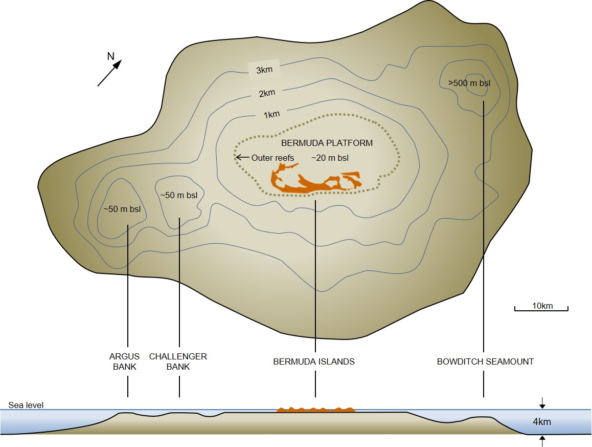
The Bermuda volcanic seamount which rises over 4000 m (13000 ft) from the Atlantic seafloor is one of a cluster of four volcanic peaks (Figure 2a). This cluster is rooted in the North American tectonic plate which is “drifting” in a generally north-westerly direction. This movement is driven by “seafloor spreading” at the Mid-Atlantic ridge, where new oceanic crust is being generated (Figure 2b). The resultant widening of the Atlantic Ocean, at a rate of approximately 2.5 cm (1 in) per year, is causing the distance of Bermuda from Europe and Africa to continually increase.

In the Pacific Ocean the 6000 km (3700 miles) long Hawaiian chain of volcanic seamounts is known to have formed by the passage of oceanic crust over a stationary plume of active magma called a “hot spot”. A similar origin has been proposed for the cluster of seamounts at Bermuda. However, apart from being very short in length, it is aligned perpendicular to the direction of movement or “drift” of the North American plate, which belies an origin similar to the Hawaiian chain. The alignment of the Bermuda cluster can, instead, perhaps be explained by eruptions along a line of weakness, or a fracture, in the ocean crust. The trigger for these eruptions is not known with any certainty, but some possibilities are explored by Vogt (VO1).
Based on re-examination, in 2019, of material from a deep drill-core extracted from a borehole on Bermuda in 1972 (see later), it has now been concluded that Bermuda’s volcanic lava was sourced from a previously unknown type of magma reservoir within the Earth’s mantle (MA4) . It is inferred, from the unique chemistry of the lava, that the Bermuda volcanic cluster was not as deeply rooted in the mantle as other intra-plate oceanic volcanoes.
The question of vertical stability
The Bermuda seamount is unusual in another way. In comparison to many of its counterparts at other localities around the world, it appears to have undergone little net subsidence, which is normally associated with loading and cooling (CL2). This being so, the subsidence model which was developed by the naturalist Charles Darwin (DA3) to explain the evolution of circular coral reef tracts (fringing, barrier and atoll) associated with many oceanic islands, cannot apply to Bermuda.
Depths to volcanic rock beneath the Bermuda islands averages 45 m (150 ft) below sea level; whereas in other dormant oceanic islands this depth can exceed 1000 m (3000 ft). What is more, the volcanic rock found at the top of Bermuda seamount includes submarine pillow lavas. Had there been significant subsidence these shallow rocks would comprise exclusively sub-aerial deposits which accumulated on the land, as opposed to deposits which formed under water. Adding to the case against subsidence is the bathymetric “rise” or “swell”, of up to 500 m, in the sea floor surrounding Bermuda.
Darwin never visited Bermuda and no boreholes had been drilled into the volcanic rock during his lifetime. He was, however, able to deliberate on the morphology of the Bermuda Islands from afar, with the benefit of Lieutenant Nelson’s account (NE1) of the islands’ geology. Darwin noted “considerable differences” (DA3) between Bermuda and other seamount islands – differences which he considered to be inconsistent with subsidence. Among them was the elevation of Bermuda’s limestone islands, with a high point at 80m (260ft), as well as the occurrence on the islands of elevated ancient marine deposits (which are now well documented at many localities as related in Chapter 4). Darwin did not coin the term, but no doubt would have concurred with the characterisation of Bermuda and its reefs as a “pseudo-atoll”.
A unique set of circumstances at Bermuda, that counteracted a normal tendency of a volcanic seamount to subside, is inferred. This may have been related to prolonged or recurring volcanic activity associated with a hot spot or to some uncommon phenomenon which supported the crust against subsidence. In the absence of evidence for an existing thermal anomaly, Frazer and Park (2026) (FR1) postulated that magma of lower density than the surrounding lithosphere had been injected beneath Bermuda, forming a buoyant “underplated layer”. Analysis of data from a seismic monitoring station on Bermuda indicated the presence of such a layer in the form of 20km thick zone of intermediate seismic velocity. It was reasoned (FR1) that this less dense layer formed during, or soon after, volcanism which had created the island. Uplift was maintained by the effect of density differences rather than a persistent thermal plume.
The absence of subsidence at Bermuda, should not be mistaken for tectonic stability. Net uplift is not ruled out, for example. The unsafe assumption of vertical stability of the seamount, on which numerous widely cited accounts of Bermuda’s sea level history (LA2,HA1,LU1,ME2,HE7 etc) have been predicated, has become untenable. The occurrence of earthquakes, faults and fissures (Chapter 10) and the predicted effect of glacio-isostic adjustment (Chapter 8) on Bermuda only serve to strengthen the case against stability.
Deep drilling and age determination
As a result of millions years of wave erosion, the volcano which forms Bermuda’s foundation was eroded into a flat-topped seamount, or a submerged volcanic stump. This submarine edifice was ultimately capped by limestone and modern carbonate sands (Figure 1e, Chapter 1). Today, no undisturbed, in situ volcanic rock is to be found anywhere above sea level.
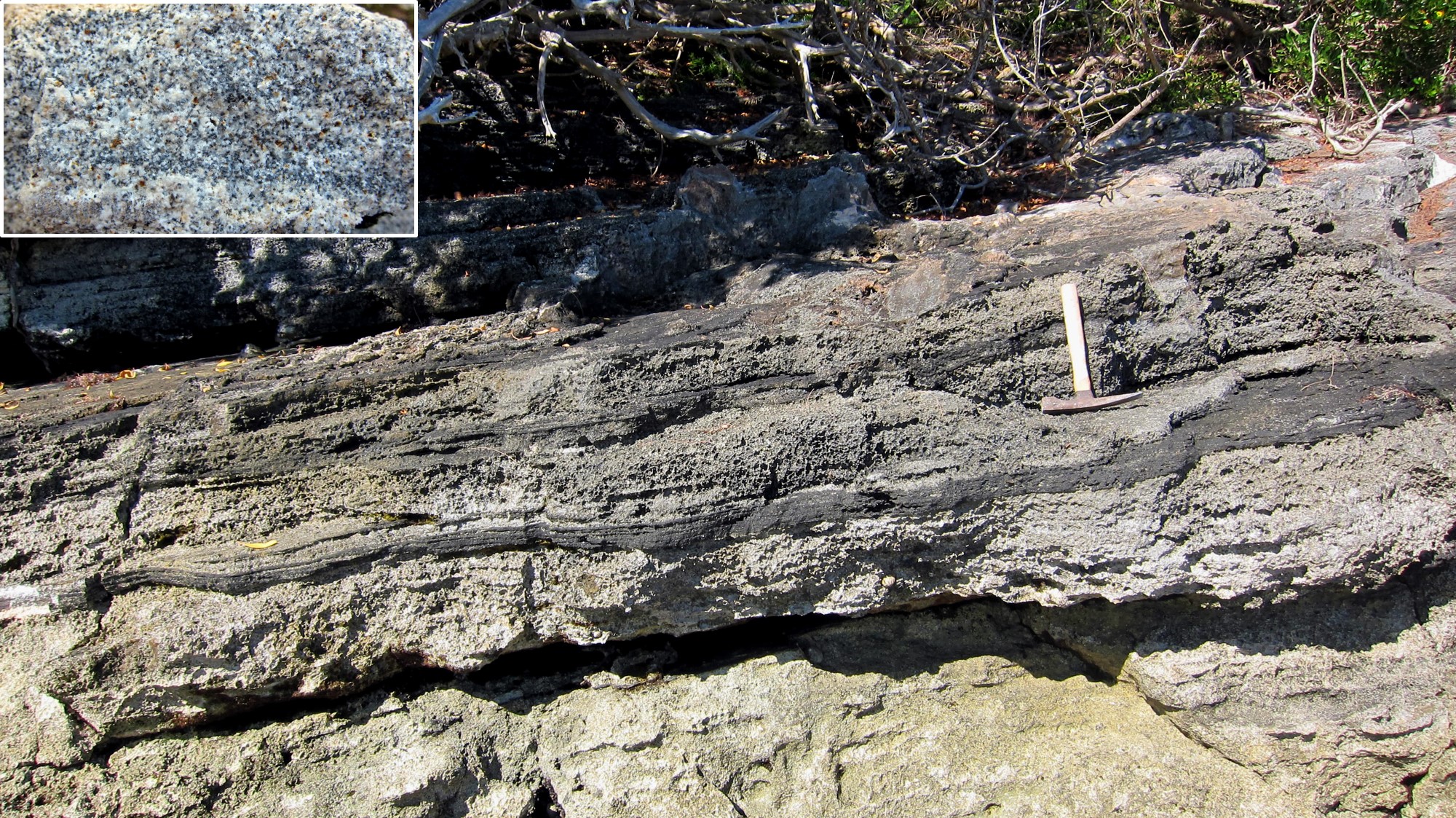
The first borehole to penetrate though Bermuda’s limestone cap into the volcanic seamount was drilled near Gibbs Hill Lighthouse in 1912 by Louis Pirsson (PI1). Volcanic debris was recovered in the drill core from a depth of 75 m (245 ft) below sea level. Undisturbed volcanic rock was not encountered until 171 m (560 ft) below sea level. It is now known that this borehole happened to be located in a part of Bermuda where the top surface of the volcano is unusually deep.
In 1972 the “Deep Drill” project (RE1) was responsible for completion of the deepest borehole drilled on Bermuda to date. It was situated on St George’s Island, just west of the Biological Institute of Ocean Science (BIOS). Volcanic rock was first encountered, below the limestone cap, at 26 m (85 ft) below sea level. A continuous rock core was extracted to a depth below sea level of 793 m (2632 ft). The core material recovered from this borehole was the source of a reliable 33.5 million years age for intrusive magma, as determined by Potassium-Argon radiometric dating (RE1). The ages of 47 to 91 million years determined for the older lava flows were not considered reliable.
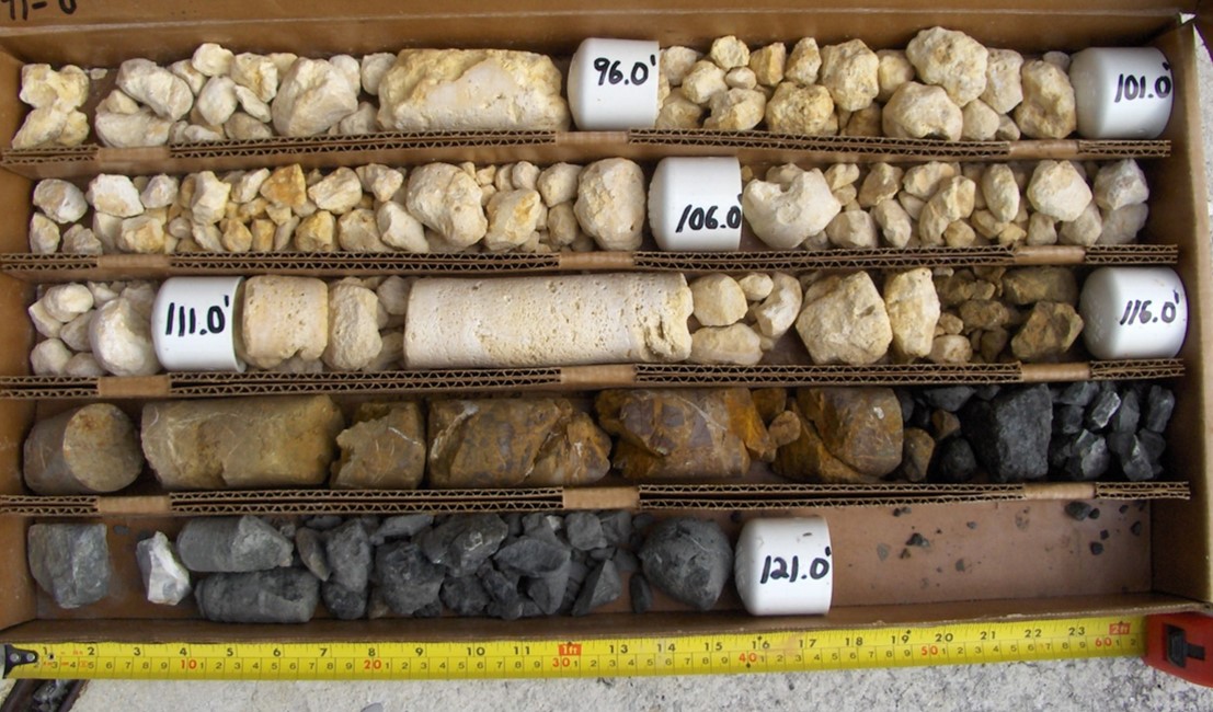
Depths to Bermuda’s volcanic rock have now been measured in over 20 boreholes (download Tabulated data). From this information it has been determined that the average depth to volcanic rock in Bermuda’s central and western parishes is approximately 45 m (150 ft) below sea level; whereas depths at the east end of Bermuda range from 23 m (75 ft) to 32 m (104 ft) below sea level (Figure 2c and 2d). This variation is consistent with evidence, in the form of volcanic sand (at Whalebone Bay) and volcanic pebbles (at Stokes Point and Government Quarry), which indicate that the last remnants of the volcanic island persisted longer, and at a higher elevation, at the east end of Bermuda than in other parts. (Figure 2d).

Remnants of calderas?
Near-circular bodies of water enclosed by a chain of small islands and/or arcuate shorelines have been singled out as potential manifestations of submerged volcanic calderas on Bermuda. A caldera is a large circular basin formed by the collapse of a magma chamber below a volcano. Best known among the purported calderas on Bermuda is Castle Harbour. Its southern shoreline consists of Bermuda’s oldest limestones, of the Walsingham Formation. These limestones, it has been surmised, were deposited around the perimeter of the ancient caldera before it was removed by erosion. Seismic reflection transects across Castle Harbour undertaken by Gees and Medioloi (GE1), to determine the structure of the submerged bedrock, revealed several prominent reflector surfaces. One of these, which was interpreted as the contact between limestone and underlying basalt, was found to form an irregular shallow basin. This was considered consistent with the caldera hypothesis. However, with information from only one nearby borehole available to calibrate the seismic data, the study must be considered inconclusive.
The preservation of calderas is doubtful when taking into account evidence presented earlier that the Bermuda Seamount has undergone little if any net subsidence, and that as much as 1000 vertical metres (3000 ft) of what was once a volcanic island has been removed by erosion. Even the largest of calderas would, by now, no longer exist. Basin-like structures which are preserved, as at Castle Harbour, can be explained as the product of limestone dissolution.
A case for Pleistocene activity ?
As noted above, survival of topographic or bathymetric manifestations of a caldera on Bermuda is not consistent with 30 million years of dormancy and marine erosion. Any suggestion of much more recent volcanic activity which could have produced a caldera is likely to be very controversial. Other than putative calderas, what other potential evidence is there for recent activity? Foremost among the contenders is faulting, which has been identified within Bermuda’s Pleistocene limestones (see Chapter 10). This can arguably be attributed to mid/late Pleistocene expansion and contraction of the seamount associated with, largely non-eruptive, volcanic re-activation.
The case for Pleistocene reactivation is deemed worthy of serious deliberation when the evidence is taken collectively. This includes: the aforementioned unexplained faults and fractures in the vicinity of Castle Harbour (at Tucker’s Point, Wilkinson’s Quarry, Government Quarry, Ferry Reach and St David’s Head) (RO4), the relatively shallow depths to volcanic rock in the same area, and the occurrence of small amounts of volcanic sand and/or pebbles preserved within the Pleistocene limestones at Whalebone Bay, Government Quarry and Stokes Point. (Figure 2e).