Types of marine deposits and their distribution
Carbonate sediments deposited by the sea and preserved as ancient marine limestone are scarce on Bermuda relative to wind blown dunes, or eolianites. The reason for this is that sea levels over the last two million years or so were predominantly much lower than today. Most marine deposits are therefore submerged.
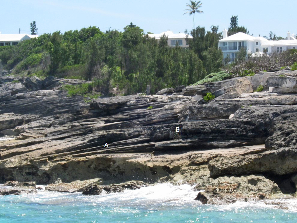
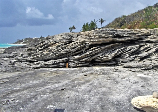
The majority of ancient marine limestones that do exist on Bermuda are concentrated in a narrow zone along the south shore in the central parishes. Although they can be similar in appearance to eolianites, they may be distinguishable on the basis of 1). their stratification, 2). their relationship to adjacent deposits and 3). the size of their particles, or clasts. Pebbles, cobbles or large shells, for example, can be readily transported by wave action in the sea, but not by the wind (Figures 4a and 4b).
Deposits of ancient marine limestone on Bermuda, and the environment in which they accumulated, can be identified through comparison with modern sediments. “The present is the key to the past” is the principle on which this approach is based.
The three main types of ancient marine deposits on Bermuda are:
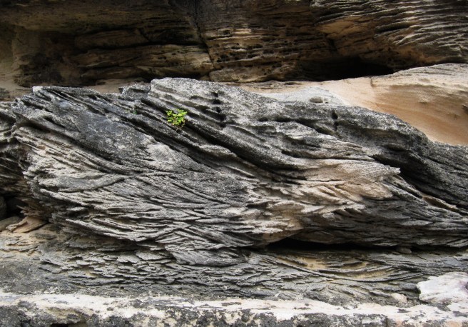
- Beach (foreshore) deposits. Many of Bermuda’s marine deposits accumulated on the foreshore as sandy beaches, and are characterised by large scale, parallel, planar strata which dip down at approximately 10° towards the sea (Figures 4c and 4f). These strata represent the “beach face” or “swash zone”, which can be observed on modern beaches as a seaward sloping wave-washed ramp. At the top of the beach face is the “berm” – a near horizontal platform which transitions landward into the dry upper beach. The landward edge of the upper beach merges into vegetated dunes, known as foredunes (Figure 3a, Chapter 3) . In the geological record, the berm and upper beach are represented by near-horizontal strata which can feature trace fossils of crab burrows (Chapter 9) .
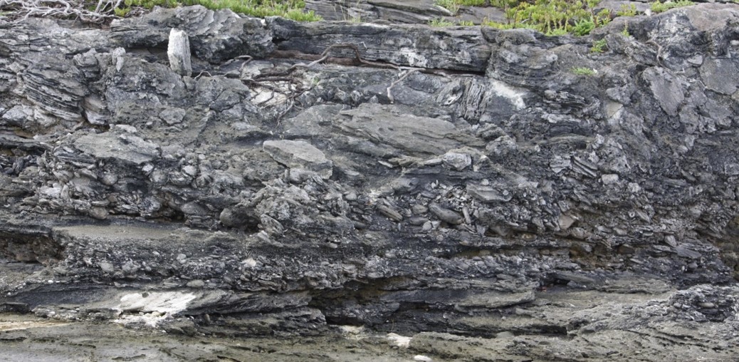
- Sub-tidal (shoreface) deposits. These deposits form below sea level immediately offshore from the beach in a high energy zone subject to wave action and associated oscillating currents . The rippled sediment surface that forms in this enviornment is manifested in the geological record by a variety of small to medium scale cross-strata which dip at up to ~20° to horizontal in a variety of directions (Figure 4d).
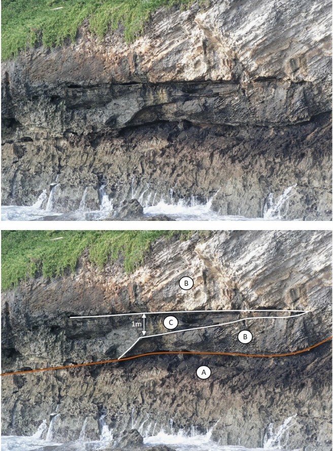
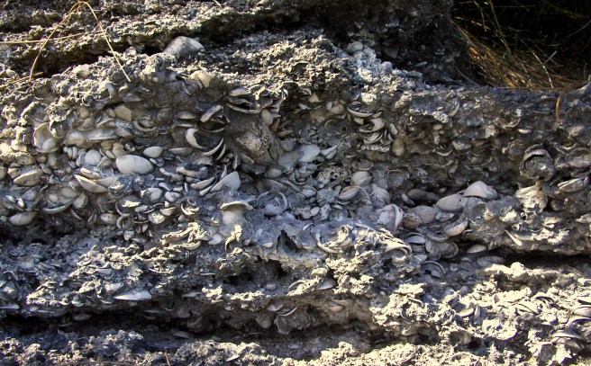
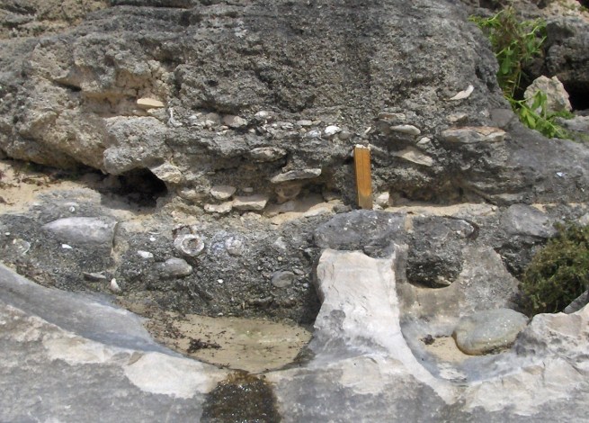
- Erosional debris. Rocky shores where beaches are not forming are subject to wave erosion. Much of the product of this erosion is transported away, along the shore or into deep water. Occasionally it is preserved as a plaster on the surface, or in a notch, of a rocky shore. This accumulation of eroded debris consists primarily of limestone fragments ranging in size from pebbles to boulders. Held together in a matrix of cemented sand, they are preserved in the geological record as a “conglomerate” or “breccia”, (Figures 4a, 4e) .
The significance of Bermuda’s ancient marine deposits
The significance of ancient marine limestones preserved “high and dry” on Bermuda today, is that they record positions of relative* sea level which were as high or higher than that at present. By establishing the age of these marine deposits, through dating of coral fragments (Chapter 9), valuable knowledge of sea level history over the last half million years has been acquired. Pleistocene sea-level data from Bermuda has, because of its assumed global significance, featured in numerous articles in highly respected scientific journals and has been the subject of much debate. (LA2, HA1,VA2,HE2, HE5,MU2,RO4). Further discussion of this topic is provided in Chapter 8.
Beach and sub-tidal deposits as (relative) sea level indicators
The form, or topography, of a sediment surface – be it rippled, flat or undulating – is diagnostic of the environment in which the sediment was deposited. In ancient marine deposits, the geometry of the stratification exposed in a rock face, represents the changing topography of the sediment-surface. The stratification, therefore, informs us about characteristics of the depositional environment, such as the energy of waves or currents and the water depth, or relative sea level (Figure 4d).
The beach face is recognisable in the geological record by its planar strata which slope seaward at an angle of 10 degrees or less. (Figure 4c). Beach face strata cannot, however, be conclusively identified unless they are found in physical contact with other deposits which are members of the beach system, such as the upper beach, or berm, or sub-tidal deposits of the upper shoreface (Figure 4f). Depending on the wave conditions at the time of deposition, the top of the beach-face in a microtidal environment, such as Bermuda, can vary in height from less than 1 m (3 ft) to greater than 2 m (7 ft) above mean sea level. The elevation of the lowest strata of the beach face is a more stable indicator of sea level. On Bermuda’s modern beaches, the base of the beach face is at approximately 0.5 m (2 ft) below average sea level.
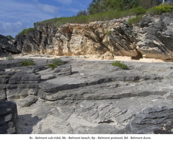
To seaward of the beach in water depths of less than two metres is a high energy environmental zone known as the upper shoreface. Sub-tidal sand ripples formed by waves or tidal currents in this zone are recorded in the geological record by chaotic, truncated sets of small scale cross-strata (Figure 4d).
The beach step is a sub-tidal feature of the upper shoreface. On many modern beaches, it comprises a short steep ramp which is created by the scouring action of breaking waves at the base of the beach face (Figure 4g). In the geological record it is represented by steep parallel, seaward dipping strata of less than 1 metre length usually found below beach face strata (Figure 4f). Because formation of a beach step is constrained vertically within a narrow range close to average sea level, the beach step when preserved in the geological record is a robust indicator of past sea level elevation (DA2,RO4) (Figure 4h).
Conglomerates and erosional features as sea level indicators
Cemented conglomerates which comprise wave-worn erosional debris are found at numerous localities along Bermuda’s south shore in Paget, Devonshire and Smith’s Parishes. Through U-series dating of coral fragments found therein, the majority of these conglomerates have been assigned to the Rocky Bay Formation (Age: ~120,000 years) and a few to the Belmont Formation (Age: ~200,000 years). Older conglomerates do exist (HA1,HE2) but the age data is nowhere near as reliable as for the younger deposits.
Marine conglomerates, preserved five to ten metres above present sea level on Bermuda’s shores, have been enthusiastically embraced as sea level markers – more so than is perhaps justified. Only when found in combination with some other subtidal, intertidal or supratidal feature – can the elevation of a conglomerate be considered of value to high resolution sea level studies – i.e. to an accuracy of one or two metres. A distinctive erosional “notch”, or “shoreline angle”, is potentially such a feature (Figure 4i). If correctly identified, it is (Figure 4j) is diagnostic of past marine erosion at an elevation which is within reach of seasonal storm waves i.e. 1 to 2 metres above mean sea level.

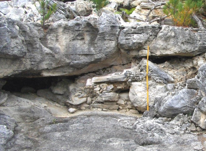
The most conclusive combination of a conglomerate and an erosional notch on Bermuda occurs on the east-facing coast of St. David’s Island. Cut into a Town Hill Formation cliff, the flat-topped erosional notch is infilled with a pebbly conglomerate at approximately 5 m above present mean sea-level (Figure 4k). Based on the planar nature of its upper horizontal surface, it can be concluded that the notch does not represent storm-wave erosion but, rather, protracted inter-tidal mechanical and biological erosion associated with a lingering sea level “highstand”. There is no age data for the feature, but because of its good state of preservation on a very exposed stretch of shoreline, it is assumed to be young and therefore, likely, a product of the Last Interglacial period. The infill material would therefore be assigned to the Rocky Bay Formation marine member.