Summary
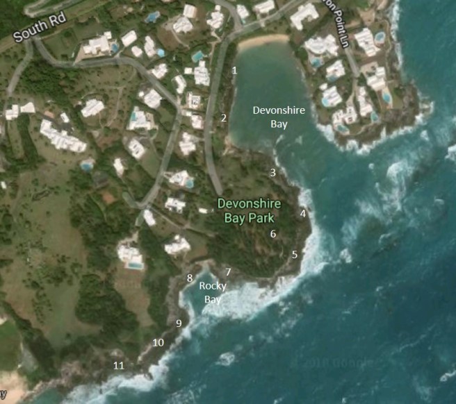
The length of the coastal exposure at the Devonshire Bay locality is approximately 650 m (0.4 miles). It is recommended that not less than 2 1/2 hours be allowed to walk the route while following this guide.
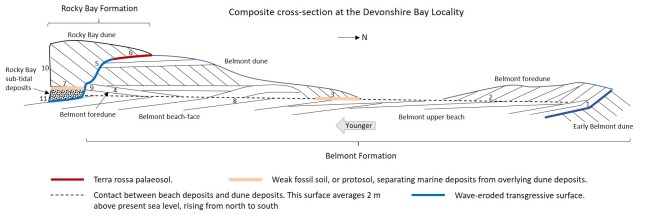
The oldest geological feature of significance preserved within the Pleistocene limestones at the Devonshire Bay locality is an erosion surface truncating what are interpreted as early Belmont Formation dunes at Section 1. The responsible event – a rising sea level, or marine transgression – occurred approximately 200,000 years ago at the Penultimate Interglacial period. A Belmont beach with associated foredunes formed on the erosion surface and built out, or prograded, in a seaward (southward) direction as sea level peaked. An extensive tract of upper beach deposits and thickening beach-face deposits, extending southward through Sections 2, 3 and 4, attest to the impressive scale of this beach’s progradation, attributable to a high sediment supply. The youngest representatives of the Belmont Formation, at Devonshire Bay, consist of dune deposits featuring slip face strata. These eolianites, found at Sections 3, 4 and 9, record the advance of mobile dunes from beaches that existed beyond (to the south) of the present shoreline, presumably at a time of sea level retreat.
A terra rossa soil formed over the emergent Belmont deposits following the fall in sea level associated with the Penultimate Glacial period. Evidence of this soil is preserved as solution hollows lined with “red” clay remnants, as seen between Sections 2 and 4 and between Sections 8 and 9. At Section 6 this palaeosol is at a sufficient elevation (>10 m) to have escaped marine erosion. However, its exposed hill-top location, at Section 6, hindered its development into a mature terra rossa palaeosol.
A major marine transgression, dated to the Last Interglacial period, approximately 120,000 years before present, was responsible for stripping away much of the aforementioned palaeosol at low elevations. It eroded the Belmont Formation deposits, which by this time had become well-cemented, or lithified. The resultant debris, including coarse sand, pebbles, angular rock fragments and broken shells, was deposited against the eroded Belmont ravinement surface as sea level rose to a maximum level of approximately 5 m (15 ft) above present mean sea level. These transgressive marine deposits belonging to the Rocky Bay Formation are best seen at Sections 5,7 and 9.
Following peak sea level a weak soil, or protosol, developed over the Rocky Bay marine deposits. This soil represented a short period of low sand supply and of plant growth, at a time when the locus of foreshore sediment deposition had moved southward. Eventually a falling sea level exposed marine sands on widening beaches which supplied landward advancing mobile dunes. Their eroded remnants are preserved today in the cliffs at Sections 7 and 10, in the form of cross-stratified eolianites of the Rocky Bay Formation.
Section descriptions
Sections 1, 2, 3 and 4
Steep northwesterly dipping dune strata at the start of the route at Section 1 near the west end of Devonshire Bay beach, are truncated and deformed at an erosion surface. Overlying this surface are low angle beach strata of the Belmont Formation and a contemporaneous foredune. In the vicinity of Section 2, near-horizonatal upper beach strata with some minor scarps grade into, or onlap, Belmont foredunes. Further south, towards Section 3, upper beach deposits transition in a seaward (southward) direction into thickening beach-face deposits. On either side of the small beach, just beyond Section 2, soil-lined solution hollows represent the remnants of a post Belmont palaeosol – the “Shore Hills”.
At Section 3, there are steep ( at 30°) dune slip-face dipping down towards the northeast which was the direction of the dune’s advance. These strata overlie truncated beach-face deposits of the swash zone which dip (at 10°) to the southwest. Intervening between the beach and the dune deposits is a thin weak fossil soil, or protosol. At a lower elevation, to the south of Section 3 the beach-face deposits feature karst solution pits which developed at the base of the Shore Hills palaeosol, now stripped away.
Towards the seaward end of the headland, at Section 4, a foredune is directly superposed on a surface which truncates the beach-top. This foredune is later and at higher elevation than those noted at the start of the route (at Sections 1 and 2). It forms the core of the hill on which the “Devonshire Bay Battery” (Fort) is situated and is over-topped by a later mobile dune which includes high angle northwestward dipping slip-face strata. The increasing elevation of the foredunes and thickening of the beach deposits, in a generally southward direction between Sections 1 and 4, reflects an increase in elevation of the beach-dune contact. It rises from 1.2 m (4 ft) above mean sea level at Section 1 to 2.7 m (9 ft) above mean sea level at Section 4.
Interpretation of Sections 1,2,3 and 4
Belmont Formation deposits including a transgressive surface, at the northern starting point, (Section 1) record a rise in sea level, or marine transgression, onto a partially cemented earlier (probably Belmont) dune. The deformation of the slip-face strata of this early dune is somewhat puzzling. The simplest explanation is the dune was battered by a large wave, or waves, when it was only weakly cemented. From Section 1 through Section 2 the low angle beach deposits locally onlap the foreslopes of the foredunes. The upper beach and beach-face deposits extend seaward a distance of nearly 200m (from Section 1 to Section 4). This represents the building out, or progradation, of the beach along with associated foredune ridges, under conditions of high sediment supply. That the prograded Belmont beach was susceptible to flooding, is inferred by truncation of the beach-face strata at a horizontal (sparsely) shelly layer. The foredune ridges formed, or re-formed, above this horizon and therefore postdated the beach at this section (as well as at Section 8) unlike at Sections 1 and 2 where the two formed contemporaneously. Construction of the last foredunes coincided with the onset of a period of sediment stabilisation and plant growth recorded by an inter-Belmont Formation protosol (Section 3a). This hiatus is thought to have been associated with a peaking sea level approximately during Penultimate Interglacial period. It preceded the formation of a Belmont advancing dune which encroached from a beach presumed to have emerged, and widened, in response to a falling sea level, or a marine regression.


Sections 5 and 6
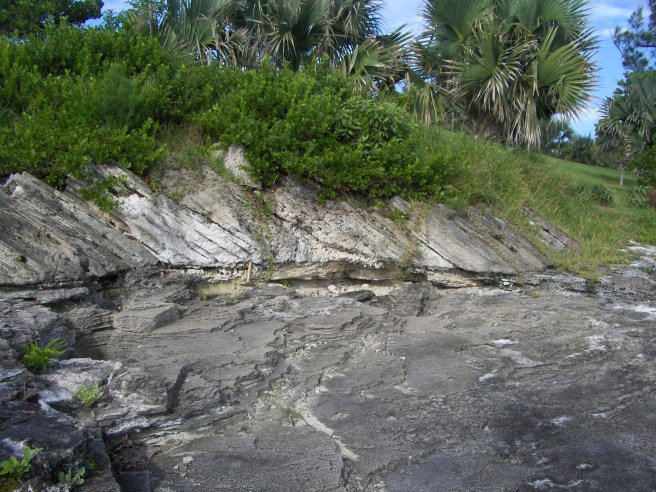
Rounding the headland and continuing along in a generally westward direction, there is a vertical transition from Belmont formation beach deposits upward into a Belmont dune which forms the bulk of the hill. At Section 5 a cemented deposit of limestone rubble, or breccia, records an episode of marine erosion. Resting at an elevation of 5 to 6 m above present sea level, it appears to be a surface deposit. However, on closer inspection it can be seen to occupy the contact between the Belmont Formation and the younger steeply dipping slip-face strata of a Rocky Bay Formation dune. This contact extends at a steep angle down the shore towards the south west.
Heading uphill away from the coast into the remains of the old fort there is a pathway excavated through limestone at Section 6. In the rock face on either side of the pathway is a southward dipping terra rossa palaeosol which separates Belmont dune deposits, or eolianite, from a later Rocky Bay eolianite. This represents the inland, terrestrial, version of the formation boundary – the breccia – seen at Section 5.
Interpretation of Sections 5 and 6
Belmont formation deposits underwent cementation, or lithification, prior to their partial submergence by rising sea level, or a marine transgression. This flooding coincided with the acme of the Last Interglacial period, approximately 120,000 years bp, when sea level is estimated to have risen to 5 or 6 m above the present level. There was significant attendant coastal erosion, the products of which accumulated as conglomerates and breccias on the eroded Belmont surface, as seen on the Devonshire Bay headland (Section 5).
The post-Belmont fossil soil – the Shore Hills palaeosol – exposed along the path in the old fort, at Section 6, formed during the Penultimate Glacial period and was ultimately buried by a Rocky Bay dune. The breccia on the coast at Section 5 formed later than the soil at the end of said glacial period. The difference between the two deposits – palaeosol and breccia – is a function of the degree to which their two locations were respectively exposed to wave erosion. The soil, at an elevation of approximately 10 m above present sea level, was just beyond the reach of waves at the peak of the Last Interglacial period and so was preserved; whereas at the location of the breccia, the pre-existing soil was largely stripped away. Only a slightly brownish sandy matrix mixed in with the wave-eroded limestone debris gives any clue of a soil’s earlier presence.


Section 7
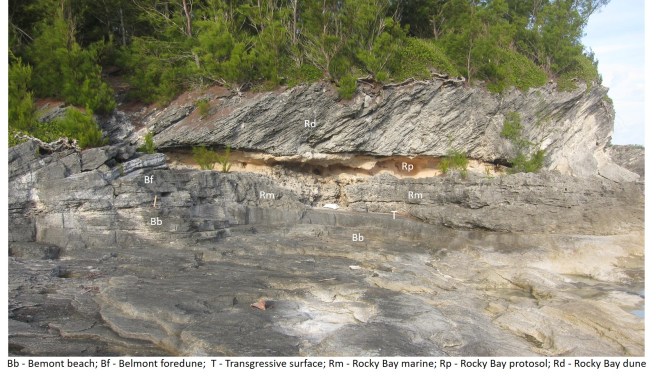
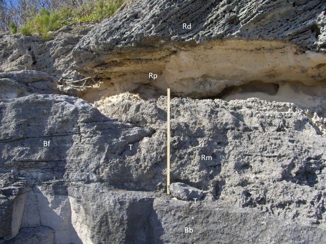
This section is approached from the southwestern corner of the car park on the path which runs alongside the boundary wall. Section 7 comprises the classic succession with which every geologist who has studied Bermuda’s stratigraphy is intimately familiar. It is where the relationship between the two most prominent high sea level deposits on Bermuda is best expressed at a readily accessible site. On the basis of the latest stratigraphic designations, consistent with the Geological Map of Bermuda, the lowest deposits within this section belong to the marine member of the Belmont Formation while those immediately above belong to the marine member of the Rocky Bay Formation (traditionally known as the “Devonshire”). The Belmont marine deposits, are simply an extension, under the headland, of those beach and foredune deposits seen along the western shore of Devonshire Bay (Sections 1 to 4). Here, the Belmont Formation limestone is bounded at its top by an eroded, ravinement, surface locally overlain by a thin deposit of rounded limestone debris, or basal conglomerate. Above the conglomerate, or resting directly on the Belmont surface, is a 1 to 1.5 m (4 ft) thick deposit of coarse poorly sorted sand. While its lower part is structureless, or bioturbated, low-angle planar stratification dipping generally southward, becomes increasingly apparent towards the top. Occasional large angular blocks of ripped-up Belmont limestone occur within these coarse sands. Next in the vertical succession is an immature fossil soil, or protosol, (traditionally known as the “Harrington”) which is , in turn, overlain by a cliff of northward dipping slip-face strata of a Rocky Bay Formation eolianite.
Interpretation of Section 7
The Belmont Formation beach at this location (Section 7) formed at a sea level approximately 1 to 2m above present mean sea level. This is evident from beach-step strata, the top of which is exposed at approximately 1m above present sea level. [At Grape Bay, to the west, the same feature occurs at up to 4m above present sea level, from which it can be concluded that Belmont marine deposits on Bermuda represent different positions of (higher-than-present) relative sea level during an oscillation, or oscillations]. Above the beach deposits and to the south is a low Belmont foredune which formed as the beach built out, or prograded, in a seaward direction. Following cementation during the subsequent glacial period, the Belmont deposits were submerged by rising seas, of the subsequent interglacial period, and subjected to wave erosion. Unlike at Section 5, where only erosional debris is preserved, here there is a basal conglomerate buried by coarse sub-tidal material of the Rocky Bay, or “Devonshire”, marine unit. The deposits, at both Sections 5 and 7, are consistent with high energy wave-erosion associated with a sea level which rose as high as 5 to 6m above present mean sea-level. It has been established by U-series dating of coral fragments retrieved from the Rocky Bay marine member that its deposition occurred approximately 120,000 years ago i.e. during the Last Interglacial period. Subsequent emergence of the marine deposits and colonisation by plants, as sea level retreated, is recorded by the fossil soil, or protosol . The last event at this location was burial of the emergent vegetated landscape by a dune which advanced from a beach situated to the south of the present shoreline.

Sections 8 and 9
Further, along the coast in a generally westward direction just past the small beach/embayment, is Section 8, which consists, exclusively, of Belmont Formation limestones. Any Rocky Bay deposits that once existed have been stripped away by wave action during the last few thousand years. Here there are well-preserved planar low-angle Belmont beach-face strata truncated at a horizontal surface, and superposed by a ridge of low foredunes with southwestward (seaward) dipping foreslopes. It is one of several foredune ridges preserved in the Belmont Formation at the Devonshire Bay, having formed as part of a seaward accreting, or prograding, beach system.
On the west side of Rocky Bay, between Sections 8 an 9, the Belmont beach deposits are locally deeply pitted with soil lined solution hollows or pipes. These are the remnants of a terra rossa palaeosol which has been largely stripped away by subsequent high sea levels. It is the Shore Hills palaeosol, which marks the boundary between the Belmont and the Rocky Bay formations. Also in this area, between Sections 8 and 9, there are several patches of Rocky Bay conglomerate including cobbles and small boulders resting on Belmont limestone surfaces. Further south, approaching Section 9, Belmont foredunes, above the beach deposits, are replaced by northward dipping slip-face strata of a landward advancing Belmont dune. At Section 9, where the coast turns more westward, the Belmont dune features a wave-cut palaeo-cliff. Plastered beneath an overhang in this cliff is a deposit of coarse Rocky Bay marine material. At a higher elevation, the cliffed remants of the Belmont dune are abutted, from the southwest, by slip-face strata of a Rocky Bay dune.
Interpretation of Sections 8 and 9
The Belmont Formation beach and foredune deposits which outcrop at Section 8, in Rocky Bay, are an extension of those deposits seen on the shore of Devonshire Bay close to Section 3. This is inferred from the orientation, or strike, of the beach-face strata which is aligned northeast-southwest. A feature which is particularly well developed here, at Section 8, is the truncation surface at the top of the beach which forms a distinctive horizontal platform at 2.5 m above mean sea level. At some localities, this platform is topped with a (sparsely) shelly layer. In this case, there are small-scale current ripple cross-strata. Backshore flooding, which interrupted foredune-ridge development, is indicated. Similar truncation surfaces recur, within the Belmont Formation, at many sites along the south shore, ranging up to 2 m higher elevation than here, for example at Spittal Pond and east of Hungry Bay.
Towards Sections 9, one of the last (youngest) deposits of the Belmont Formation at this locality is preserved. It is an advancing dune, situated to seaward of the foredunes at Section 8 and above the prograded beach. Similar to the Rocky Bay Formation dune at Section 7, it represents the mobilisation of sand on an expansive beach to seaward of the present shoreline at the onset of a fall in sea level, or marine regression. That there is a lesser volume of the Belmont dune, or eoliniate, in comparison to the Rocky Bay counterparts can be attributed to a contrasting history of marine erosion. The older Belmont deposits underwent partial submersion by a ~ + 5 m high sea level during the Last Interglacial period, causing extensive erosion, the product of which accumulated as Rocky Bay transgressive marine deposits. The Rocky Bay eolianite, on the other hand, despite having been subjected to significant Holecene storm-wave erosion, have been spared the havoc that was reaped on Belmont deposits by five more metres of submersion.


Sections 10 and 11
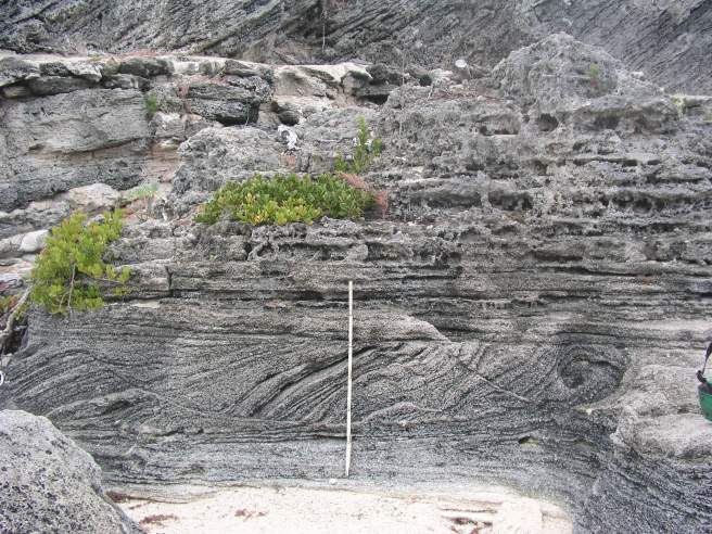
Section 10 is dominated by Rocky Bay Formation deposits which at the eastern end rest against a palaeo-cliff (see Section 9, above). At the base of the succession are poorly sorted coarse sub-tidal sands with occasional boulder-size blocks of ripped up Belmont limestone and broken remains of the large marine gastropod, Cittarium pica. Overlying this is a protosol (largely obscured by coastal protection block-work) and followed by a Rocky Bay dune which forms an 8 m (25 ft) high cliff. This sequence is the same as that seen at Section 7.
The succession at Section 11 is virtually the same as at Section 10. The marine deposits, while still coarse and poorly sorted do, however, display large scale wavy cross-stratification. The Belmont Formation limestones make a re-appearance close to sea level below the Rocky Bay marine limestone at Section 11. The contact is not always clear, but generally the latter are very poorly sorted coarse sands, with a rudaceous content, and are less well cemented than the well sorted sandy, or arenaceous, Belmont beach deposits.
Interpretation of Sections 10 and 11
A marine transgression of the Last Interglacial period is represented by basal marine limestones of the Rocky Bay Formation. The coarse, poorly sorted sub-tidal deposits accumulated in high energy conditions close to a rocky shore consisting of cemented Belmont limestone. Late in the Last Interglacial period these newly accumulated marine deposits emerged from the sea. Their colonisation by plants is recorded by the intra-Rocky Bay protosol, the “Harrington”. The hiatus in sediment deposition ends when Rocky Bay dunes advanced over the protosol and associated vegetation, from a beach which was positioned offshore, relative to the present shoreline. A fall in sea level, or marine regression, is inferred.
At Section 11 the lithology and cross-stratification of the Rocky Bay marine limestones are consistent with deposition in high energy sub-tidal environment which developed on a rocky shoreline similar to the majority of today’s south shore. As at Sections 7 and 10, the succession is topped by a protosol and a landward advancing dune indicative of sea level retreat.


Section 10b. Rocky Bay marine deposit. This coarse unsorted transgressive marine deposit features many broken Cittarium pica marine gastropods (inset) which have recently been re-introduced in Bermuda. Accumulation of this deposit coincided with a rise in sea level at the last interglacial period approximately 120,000 years ago.