
.
Terminology – Definitions and explanations of palaeo-sea-level terminology References – download a spreadsheet of references NOTE: all elevations are quoted relative to LMSL unless otherwise stated.
The relative sea level (RSL) record at Bermuda during the penultimate interglacial period (MIS 7)
Early, pre-2000 research
Extensive emergent Belmont formation beach deposits are exposed on Bermuda’s south shore. They include shoreface and foreshore sedimentary structures as well as features associated with beach cementation. Based on the elevation range of these sea level indicators early researchers placed coeval RSL at +2 to +2.5 m (3)(4). Radiometric dating of coral fragments by Harmon et al (1983) (4) confirmed that “the classic Belmont of Bermuda’s south shore represents (MIS) Stage 7”. Four U-series coral ages they measured, including one purportedly from an in-situ reef at Boaz Island, were in the range of 200 ka to 228 ka (with a precision of +/- ~20ka). Furthermore, they reported a marine layer within dated flowstone which, for them, confirmed that MIS 7 eustatic sea level peaked at +2 m at about 200 ka (4).
Accordingly, Harmon et al (1983) (4) envisaged flooding of the Bermuda platform at about 230 to 220 ka, which produced the early Belmont eolianites, followed by a highstand at about 210 to 190 ka during which RSL rose to ~ +2 m, with the extensive emergent Belmont beach deposits developing during the subsequent regression.
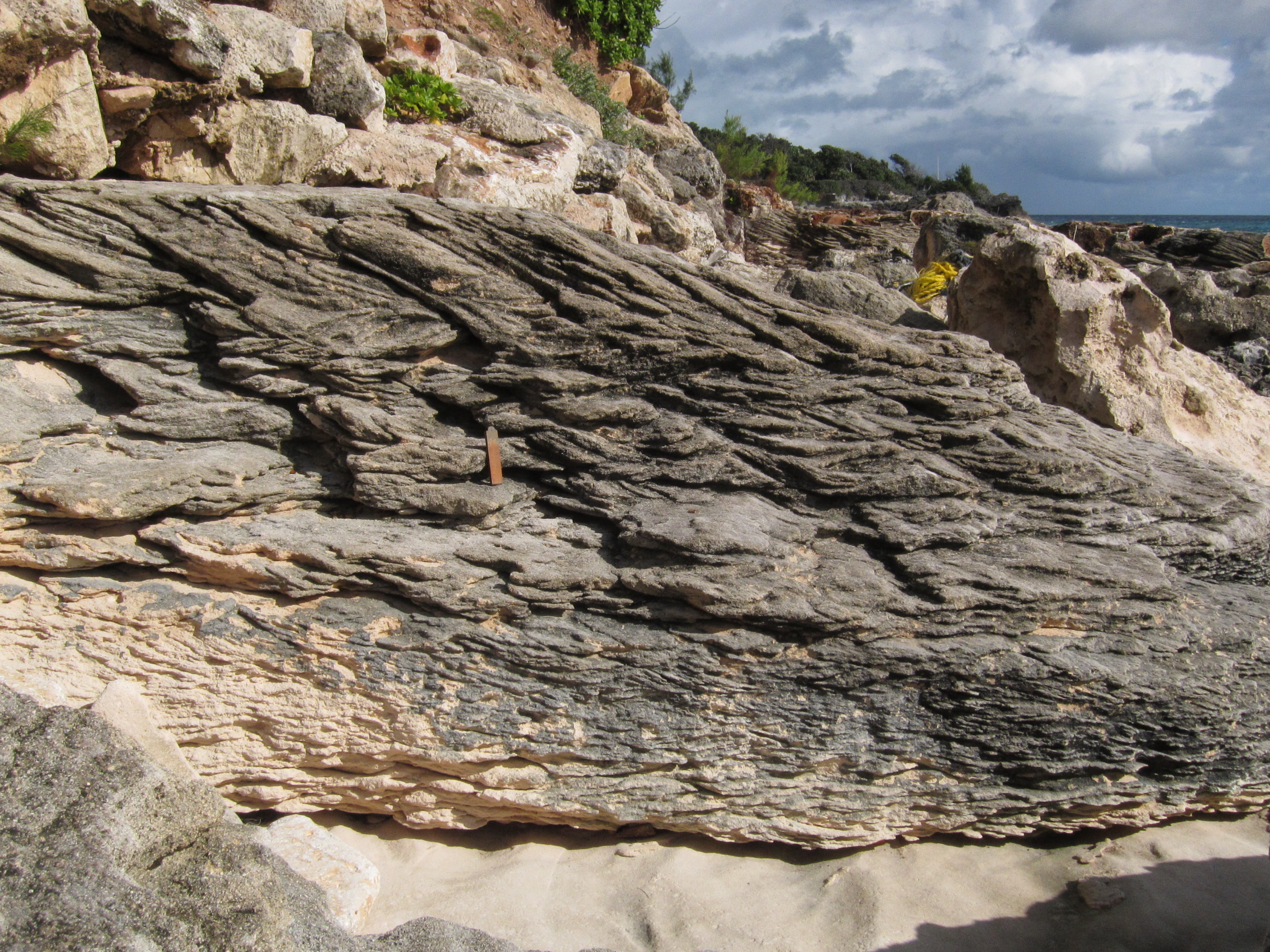
Meischner and Vollbrecht (1995, 1996) (5)(6), documented evidence of two, higher-than-present, MIS 7 highstands manifested as shoreface and foreshore deposits of the Belmont formation. The RSL elevation of their first highstand is constrained to < +1.5 m by heavily bioturbated backshore deposits, comprising trace fossils Psilonichnus upsilon (5) – land crab burrows – notably at Doe Bay (Chapter 9, Figure 9K). They inferred a second, subsequent, highstand from emergent sublittoral Belmont deposits at Grape Bay and from fenestrae (beach bubbles) at Watch Hill Park. The elevations of these marine features are indicative of an RSL which exceeded +7.5 m. The same authors (6) observed (under the microscope) isopachous crust of circumgranular low-Mg calcite in limestone collected at close to + 8 m at Watch Hill Park. Low Mg and Sr contents together with circumgranular nature suggest meteoric-phreatic (fresh ground water) origin or possibly recrystallization of a marine precursor. Either explanation requires a ~ + 8 m RSL at Bermuda which has been attributed to a second Belmont highstand (6).
Post 2000 research
Five more coral fragments from the Belmont formation of Bermuda’s south shore were dated with high precision by Muhs et al (2002) (11) and Rowe et al (2014) (25) yielding U-series radiometric ages of 201 ka, 199 ka, 198 ka, 198 ka, and 196 ka – all consistent with late MIS 7 deposition. Such consistency coupled with the correspondence of the ages with the established stratigraphy, supports the concept of a relatively short transport time – between the growth of an organism and accumulation of its skeletal remains in a clastic deposit (25). Clustered ages contemporaneous with deposition are to be expected among coral fragments which accumulated on a beach on the shore of a productive carbonate platform populated with thriving reefs. This is especially so where the fragments are clean, un-encrusted and largely unworn as is the norm for Bermudian marine fossils. These factors belie contamination of Bermuda’s MIS 7 age data by reworking as asserted by Hearty (2002) (21) who, notably, did not question similarly derived MIS 5e or MIS 5a age data.
Twelve sedimentological lithofacies or sedimentary “structural facies” (Clifton et al, 1971) were identified in the Belmont formation deposits by Rowe et al (2014) (25). These lithofacies, their associations, stacking patterns and elevation were catalogued at more than 50 localities. Based on examination of modern equivalents and on published descriptions of analogous coastal deposits elsewhere in the world, these lithofacies were attributed respectively to: the upper shoreface, the beach foreshore and the beach-backshore. Their respective indicative ranges (the elevation range in which they formed relative to MSL) (25) were applied to RSL interpretations.
The distinctive characteristics of Hapm facies, and its development as a sub-tidal beach step at a vertically constrained position on the shore, qualifies it as the foremost sea level indicator facies (SIF), of any age, on Bermuda. It exists at multiple localities in the Belmont formation at elevations from 0 m to ~ +4 m RSL. It is formed at the base of the beach face by a vortex. Its indicative range (where it forms) is -1m to 0 m RSL. (25)
Aforementioned Belmont formation lithofacies and their assoications , collectively, evidence MIS7 palaeo-sea-levels on Bermuda which ranged from close to present sea level up to several metres above it. The highest Hapm (beach step) facies found so far, at Grape Bay, attests to a Belmont mean sea level at ~ + 4.5 m RSL (Figure 8i). Evidence of a higher, + 6 m, palaeo-sea-level associated with the Belmont Formation is found at Watch Hill Park where Lapl (beach face deposits), shelly layers, fenestrae and incipient foredunes are elevated up to 2 m above their highest Belmont counterparts at other localities along the south shore (25). These interpretations are consistent with those of Meischner and Vollbrecht (5)(6) presented above.
In Chapter 13 there is a Section titled “Missing evidence of a prolonged LIG highstand at Bermuda”. The same observations made there, as regards MIS 5e relative sea levels (RSLs), apply to MIS7. In both cases, and indeed at MIS 5a and MIS 11, the sea level indicators that are documented are predominantly high energy clastic deposits, which on a geological time scale took “no time” to accumulate. Robust evidence , such as emergent coral reefs, biological notches and phreatic caves, of any past prolonged “hightand” do not exist on Bermuda. One explanation for this is that sustained palaeo-RSL elevations at Bermuda did not exceed present RSL. Only short term RSL surges are recorded.
The global relative sea level (RSL) record during the penultimate interglacial period.
Evidence of MIS 7 RSL lower than present mean sea level.
Speleothem growth-records from Argentarola Cave in Italy reveal three peaks in sea level during MIS7 (marine isotope stage 7), none of which exceeded 10 m below present mean sea level (-10 m RSL). Based on U-series radiometric dating, these peaks were correlated with sub-stages MIS 7.5, 7.3 and 7.1 with respective age ranges of 250 ka to 231 ka , 217 ka to 206 ka and 202 ka to 190 ka (43). The “highstands” at MIS 7.5 and 7.1 were more prominent than that at MIS 7.3 (37)(43). A potential fourth peak at ~180 ka is not generally considered noteworthy but nevertheless left a record in the sedimentary succession on the Bahamas Banks (68).
Based on variations in Deuterium Co2, CH4 and dust levels measured in an Antarctic ice core, Petit et al (1999) (27) concluded that present day sea levels were not nearly reached during MIS 7. Similarly, oxygen isotope analyses of planktonic foraminifers collected from drill cores in the Red Sea record peak MIS7 sea levels that were lower than the present mean level (Rohling et al, 2009) (37).
According to Sherman at al. (2014)(72), the elevation of the MIS 7 Waianae Reef in Oahu Hawaii, when corrected for uplift, is indicative of contemporaneous sea level at -9 m to -20 m RSL. They surmised that evidence found elsewhere of MIS7 sea levels reaching higher than present MSL are attributable to short-lived events which left only scattered beach deposits behind on Oahu. It is argued (72) that the formation of the prominent and extensive Waianae Reef was associated with lower sea levels of much longer duration.
Global evidence of MIS 7 RSL close to, or above, present mean sea level
Correlation between the uplifted reef terrace record of the Huon Peninsula, Papua New Guinea and the marine oxygen isotope record, suggests MIS 7 sea levels stood in the range of -20 m to nearly 0 m RSL (Chappell and Shackleton, 1986). The raised terraces of Barbados have been attributed to MIS 7 sea levels in a range −20 m to +9 m RSL, while in Curaçao, late MIS 7 paleo-sea levels from −3.3m to +2.3 m have been interpreted from uplifted reefs (71).
Several records from tectonically stable settings such as Bermuda, south Florida/Florida Keys and Grand Cayman indicate MIS 7 sea levels stood in a range of -2 m to + 2 m RSL (71). Muhs et al. (2012) (71), recognizing this “broad agreement” of MIS 7 sea level elevations, concluded that the penultimate interglacial period was a major period of warmth, on a par with the present interglacial period.
Pleistocene coastal deposits of western south Australia, indicate that sea levels at the penultimate interglacial (MIS7) did not deviate much from present sea level, reaching little more than +1 m RSL. (46). In Eleuthera and New Providence Island of the Bahamas wave-induced features including fenestrae (beach bubbles structures) have been found in MIS 7 deposits at up to +2 m, indicative of sea-level close to 0 RSL (47). MIS 7 coral reefs in south Florida are preserved below present sea level, at about -1.1 m to -1.4 m, at Long Key and above present sea level, at + 1.0 m to +1.5 m, at Key Largo. Assuming a depth of coral growth of 3m below sea level the data collectively imply MIS7 sea level of +1.6 to +4.5m at about 200 ka. (52).
Evidence from the Mediterranean of MIS 7 RSL above present mean sea level
In western Sardinia sedimentological observations and optically stimulated luminescence (OSL) age data (93) have yielded an estimated MIS 7 palaeo-sea-level elevation of ~ + 2.5 m RSL. Andreucci et al (2009) (93) consider this figure to be uncontaminated by tectonic VLM (vertical land motion), because the elevation of MIS 5e foreshore deposits in the same area are consistent with an LIG GMSL of ~ + 5 m.
In southern Cyprus, the elevation of MIS 7 marine units are indicative of a palaeo-sea-level slightly lower than that of the LIG (66). In Mallorca, Vessica et al. (2000) (77) used stable isotopes and U-series analyses of calcite overgrowths, on speleothems, to identify a MIS 7 highstand of + 4.2 m RSL. They claimed that after correction for subsidence, based on the elevation of LIG sea level indicators, eustatic MIS 7 sea level must have been significantly greater than + 4.2 m RSL imprint found in the caves.
