A gallery of miscellaneous geological features found on Bermuda:
Photo 1. Blackened Stones at Mid Ocean Beach. Blackened stones are not uncommon within Bermuda’s palaoesols. Analyses have revealed that they are not volcanic in origin, but are fragments of limestone bedrock which have been altered by biochemical processes. Strasser (ST1) who has studied the phenomenon elsewhere in the world attributes it to impregnation of the limestone with decayed or burnt organic matter.
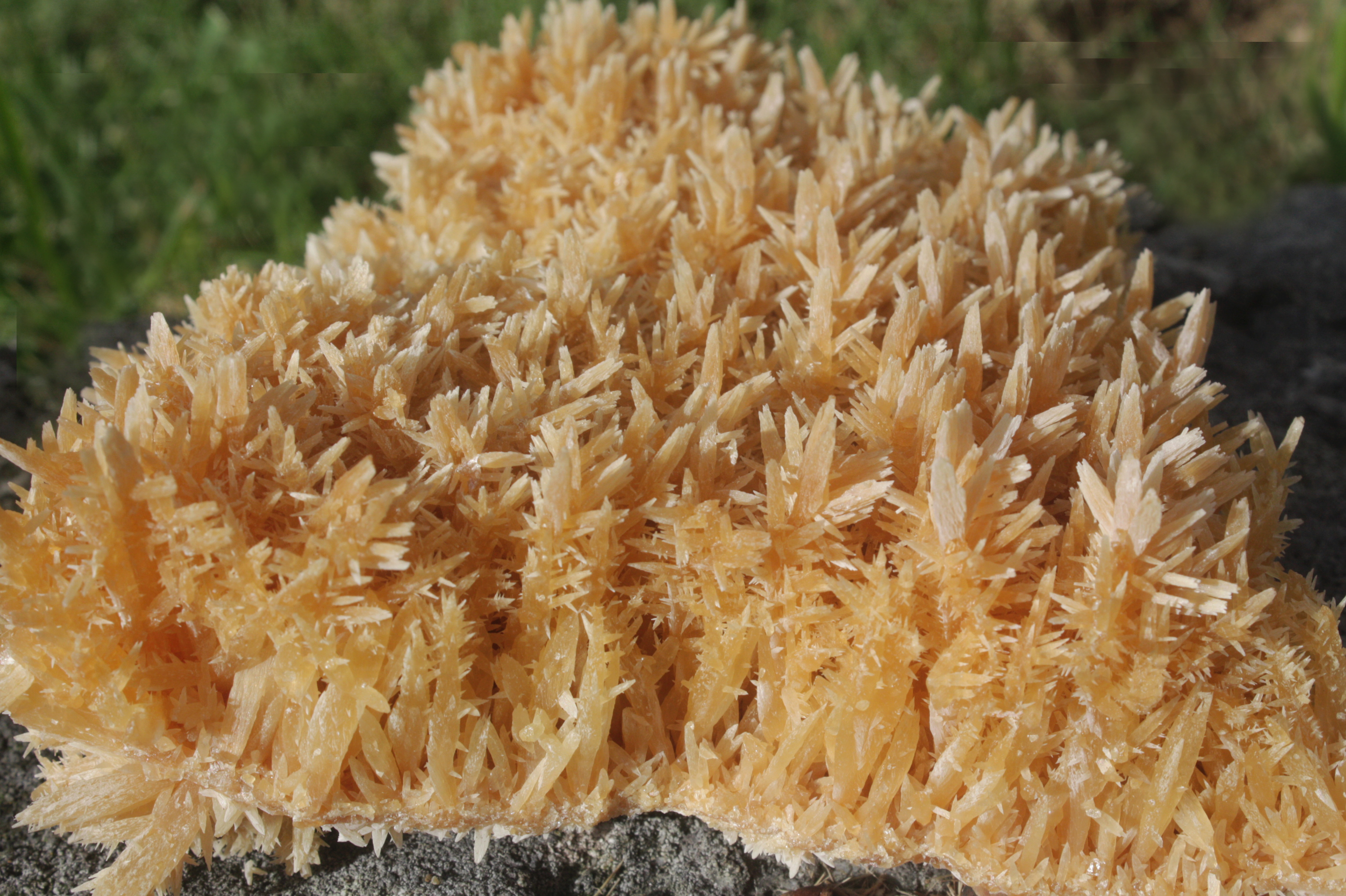
Photo 2. Crystals from Wilkinson Quarry. Calcite crystals in this type of formation, known as dogtooth spar, can form in the waters of undisturbed cave pools where calcium carbonate concentrations can build up to saturation point. (Scale: the largest crystals are approximately 1 cm, or less than 1/2 in, in length).
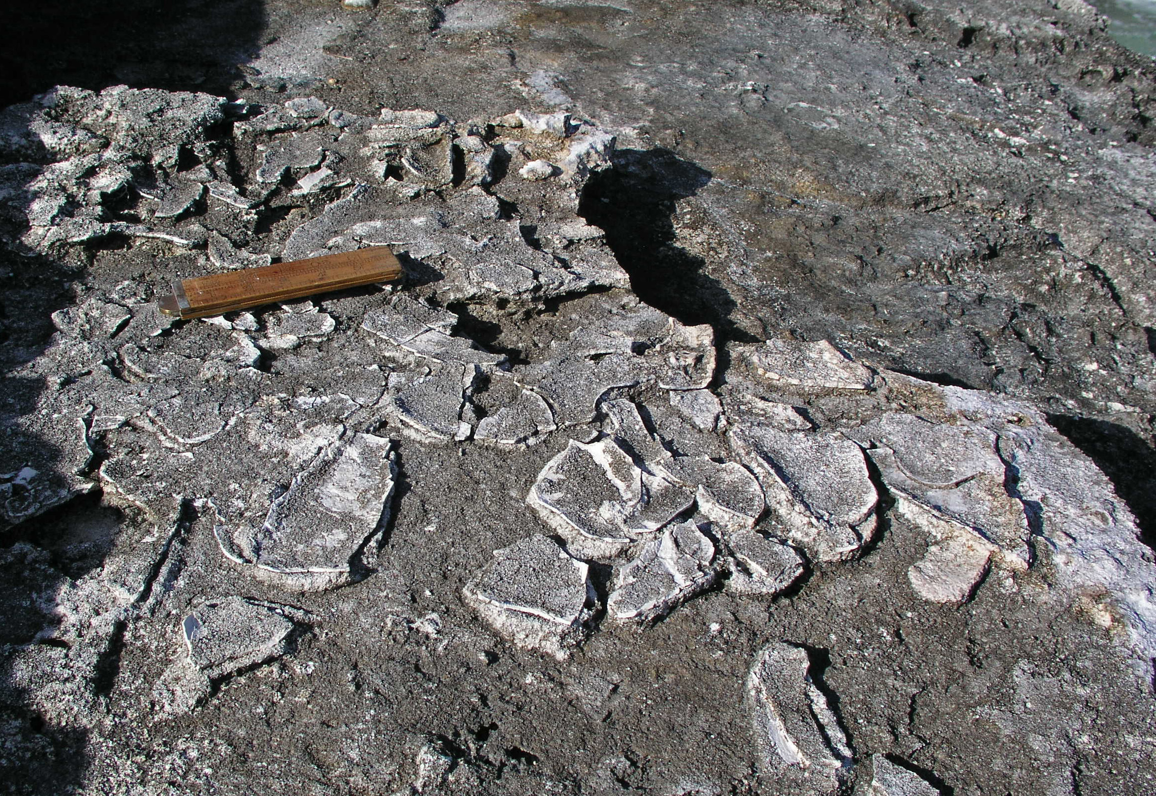
Photo 3. Ancient mud-cracks on the South Shore, east of Hungry Bay. These flat fragments of limestone were found on top of a Belmont formation beach (age: 200,000 years). They would have originated as a layer of fine silt or mud in shallow water, which drained away or evaporated. Dessication caused the layer to shrink and break apart. This sequence of events is not typically found on an active beach. A likely senario is that, as a result of progradation, this area developed into a slack – a topographic depression – cut off from the sea by a dune ridge, and was subject to occasional flooding (Scale is provided by the 6″ or 15 cm rule).
Photo 4. A boulder of peat found on a beach at Cooper’s Island. This is one of a number of large “chunks” of peat found washed up on southwest facing Well Bay Beach in March 2025. It had been ripped up by wave action from the seabed within the bay. The peat must have originally accumulated when sea level was lower than at present and the bay was occupied by marshland, or by a mangrove swamp, during the late Holocene – approximately 5000 years ago. Note the occurrence of what are thought to be black mangrove roots preserved within the peat A piece of this peat, when thown into the sea, was found to float, which explains how large pieces were transported onto the beach.(Scale is provided by the key)
Figure 5. A cliff cut into the beach at Warwick Long Bay. This cliff, known as a scarp, appeared on the beach in February 2025. It is a common feature produced by storm waves but this one, at approximately 1.5m in height, is unusually high. It features a scarped (cliffed) deposit of horizonatal strata at the top, which accumulated on the upper beach, and seaward dipping strata at the bottom which formed by avalanching. An ancient example preserved in the geoloical record can be seen near Cloverdale on the South Shore (See Figure 8a, Chapter 8). Beach scarps can be reliable sea level indicators.
Figure 6. Fossil protosl at Elbow Beach. This 1 m thick homogeneous rust coloured deposit was exposed by storm waves in 2020. Similar deposits are found elsewhere on the south shore, such as at Horseshoe Bay and Jobson’s Cove. It occurs as a layer within young uncemented sand deposits. It is best described as a protosol, representing an interruption in the formation of sand dunes. It incorporates iron rich particles transported by the wind either as atmospheric “dust” or from subaerially exposed local sources of volcanic material or terra rossa palaeosols. Most likely this occurred when when sea level had been lowered. Equivalent ancient deposits are found in Bermuda’s geological record (See Chapter 6)
Figure 7. Tilted speleothem columns in St David’s. The tilt of these columns is made apparent by comparison of their alignment to the white 1 metre rule which was set to vertical using a spirit level. This tilting, coupled with the presence of a nearby fault, is indicative of tectonic movement. The cave at >15m above sea level appears to be a rare example (in Bermuda) of a primary phreatic cave – there being no evidence of collapse.
FIgure 8. Bermuda platform 18 Oct 2014 Hurricane Gonzalo Cat 3. This satellite photo reveals the capacity of hurricane waves to generate massive plumes of sediment which originate on the Bermuda platform. The associated loss of bioclastic sediment likely takes decades to replenish and meanwhile deprives beaches of the sand supply required to survive and rebuild. The same applies to dunes.