
Summary
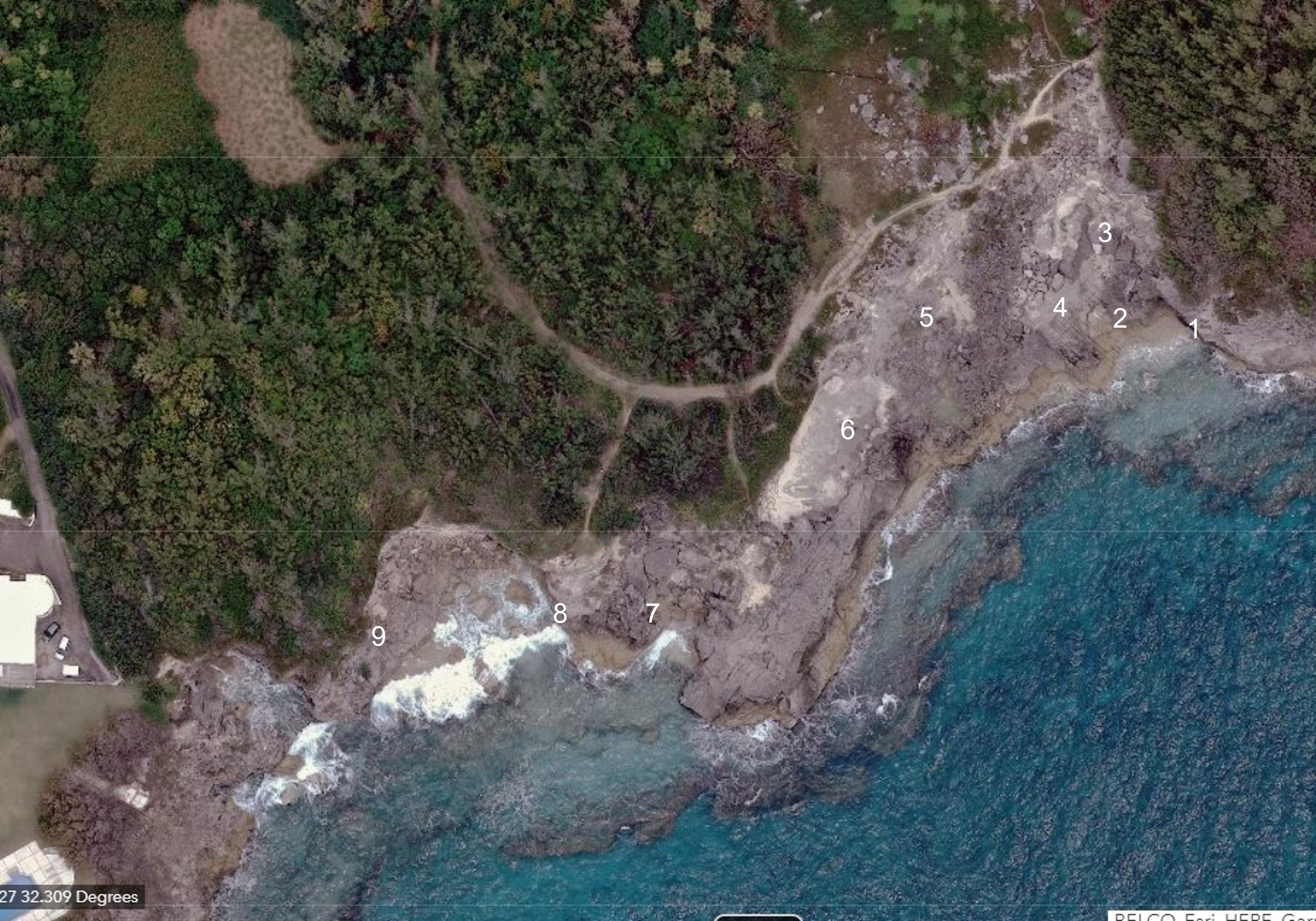
Spittal Pond has 2 car parks which are accessed from South Shore Road. For this field excursion, the western car park is recommended. The path from the car park leads directly into the path shown in the satellite image, above. The length of the coastal exposure at this locality is approximately 200 m. Some areas require agility to access, particularly towards the western end. It is recommended that not less than 1 1/2 hours be allowed to visit the sites identified on the satellite image and described below.
The exposed limestones along the shoreline at this locality belong to the Belmont Formation other than two small patches (outliers) of Rocky Bay (Devonshire) marine conglomerate. The Belmont marine deposits record a high sea level event which is attributed to the penultimate interglacial period, based on robust stratigraphical interpretation supported by a 197,000 year age yielded by a coral fragment which was collected from here (RO4). The structure and arrangement of the foreshore and shoreface (sub-tidal) deposits provide reliable evidence of a sea level which peaked at approximately 4 m (13 ft) above present average sea level during Belmont times. The locality is also noteworthy because it includes an elevated marine erosional contact and conglomerate (at Site 9) whose stratigraphic position has been the subject of much debate. Re-interpretion by the author, in the early 1980s, significantly altered the narative of Bermuda’s Pleistocene history.
Apart from the evidence, alluded to above., of two distinct high sea level events at this locality, there is an important sequence of marine deposits preserved in the dominant Belmont formation. This sequence records initial beach progradation (seaward accretion of deposits) associated with a high sediment supply during a rising sea level followed, vertically, by a near horizontal truncation surface and a protosol, which in turn is superposed by a foredune and a transgressive (landward advancing) dune. This sequence records a sea level which peaked and then began to fall. It establishes a correlation between dune-building activity and sea level change, which has been the subject of decades of debate.
Sections 1, 2 and 3
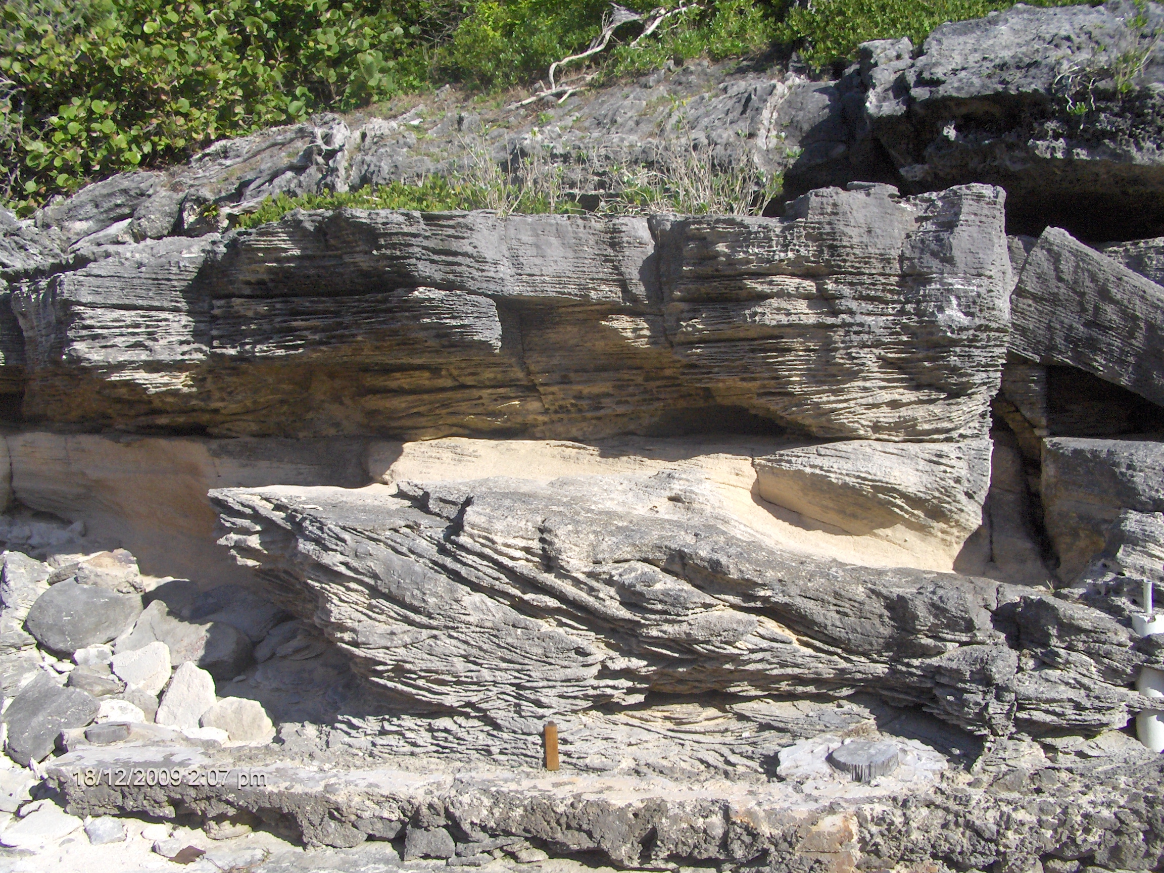
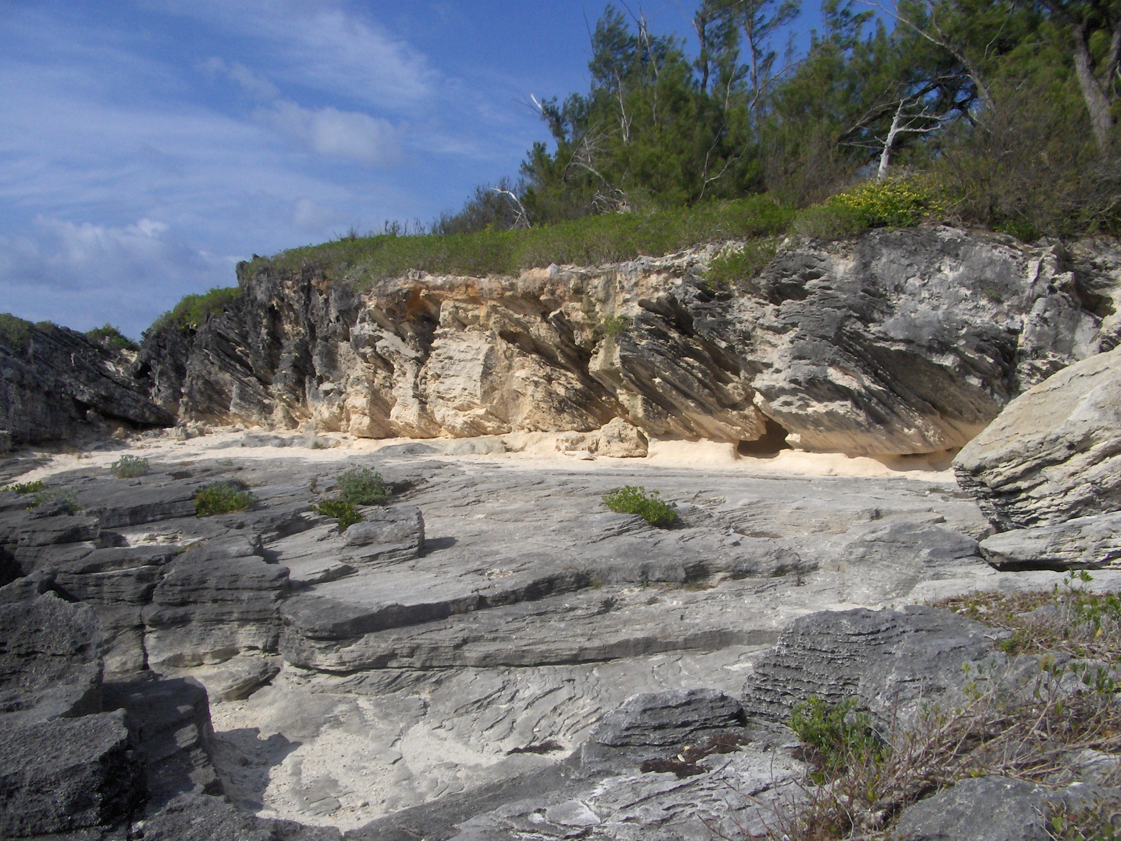
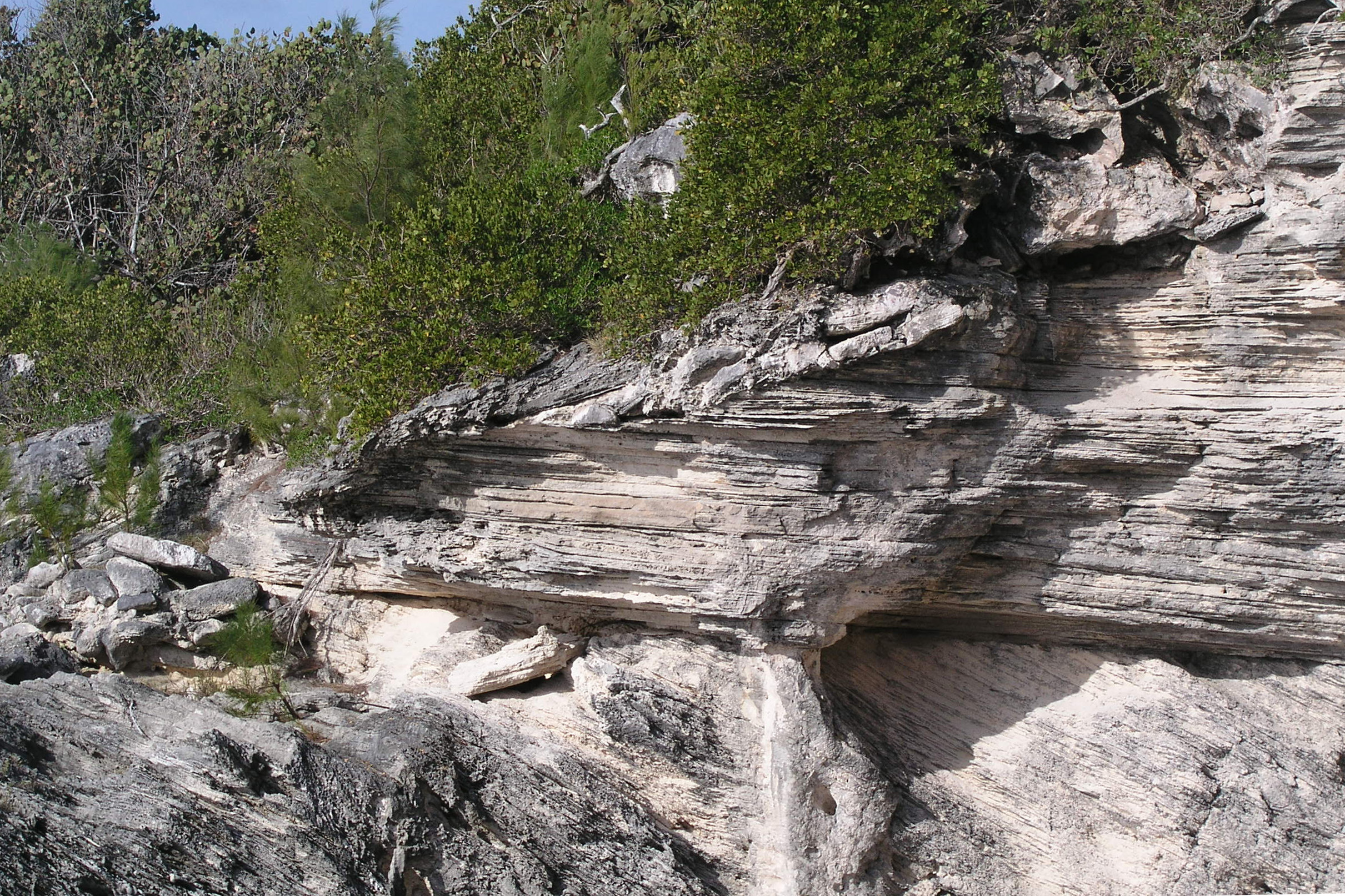
Aligned SSE-NNW, Sections 1, 2 and 3 consist of an arrangement of marine and terrestrial deposits which is repeated several times along the shore at the Spittal Pond nature reserve. At the base, near sea level, are upper shoreface marine deposits (beach step) overlain by gently seaward-dipping planar strata of the inter-tidal beach-face. A horizontal bounding surface truncates the beach-face deposits at 4.1 m (14 ft) above present sea level. Resting on this erosion surface is a protosol (weak soil) which thickens in a landward direction. At the seaward end of Section 1, where the protosol is weak or non-existent, a foredune with landward dipping strata overlies the beach deposits. Over-topping the foredune are the steep landward dipping slip-face strata of a transgressive dune. This arrangement of the deposits is exemplified in Figure 1.


Interpretation of Sections 1, 2 and 3.
These Belmont Formation sections can be summarised as prograded marine deposits and overlying eolianites (dunes) with an intervening sub-horizontal discontinuity which locally coincides with a protosol (weak soil). The presence of another protosol (A, in Figure 1) below the sub-tidal deposits infers that this succession commenced with a marine transgression onto a terrestrial backshore. The marine units include sub-tidal wave-ripples (Section 3) , beach-step deposits (Section 2 and 3) and planar sloping (~10 degrees) beach-face deposits. Their elevation indicates that sea level at the time of their deposition was at least 3.4 m (11 ft) above present average sea level. The beach deposits prograded seaward (Figure 1, below) over a distance of nearly 50 m (160 ft), which indicates a high sediment supply. A coral collected by the author from near the base of Section 2 yielded an age of 197,000 years (RO??) which correlates the marine deposits, and associated high sea level, with the Penultimate Interglacial Period, as at Grape Bay.

A sub-horizontal disconformity truncates beach-face strata at approximately 4.1 m (14 ft) above average present sea level. It takes the form of a white protosol (weak soil) at its landward end and a bounding surface at its seaward end (Figure 1). Below the disconformity are truncated gently dipping beach-face strata. Above it are dune strata. The truncation of beach-face strata occurred after the beach had prograded just as sea level peaked. At this point the backshore would have susceptible to flooding and erosion by water currents or deflation. Protosol B (Figure 1) would have subsequently developed in a backshore basin protected by foredunes.
Overlying the disconformity at the seaward end of Section 1 is a foredune with landward dipping leeward strata. This is over-topped by a mobile transgressive dune with steep (30 degrees) slip-face strata (Figure 1). This dune extends to the landward end of the exposure at Section 3. The inference is that the foredune formed at close to peak sea level concurrent with the development of the protosol. The subsequent increase in sediment supply, necessary to form a mobile transgressive dune no doubt coincided with a marine regression (fall in sea level) and resultant widening beaches.
Site 4
At this site, known as the “checkerboard”, there is a rectangular pattern of grooves carved into a horizontal limestone surface. These grooves have been interpreted as fractures whose alignment was determined by tectonic stresses which propagated from the sea floor through the volcanic seamount. Fractures are not uncommon in Bermuda, but this is an unusually dense well-defined pattern, . Recent investigations of this site by the author have shown the surface is actually the top of a protosol rather than marine limestone as had previously been assumed. As a soil, with a clay content, which formed close to sea level the protosol was likely subjected to intermittent flooding. In the process of drying out following saturation by a high tide or a high water table, there would have been the opportunity for desiccation cracks to form which developed in a rectilinear pattern.

Section 5
Medium scale cross-strata are overlain by large scale low angle (~10 degrees) beach strata. From the orientation of these strata, dipping towards the sea (left), and their relationship to each other, it is inferred that they represent the sub-tidal beach step and the inter-tidal beach face, respectively. Truncating the beach face on the right is a horizontal erosion surface superposed by a protosol and a dune with steep landward dipping slip-face strata. On the far left, in the distance above the shrubs, are strata of a foredune which is overtopped by a transgressive dune to its right.

Interpretation of Section 5
At the base of this densely cross-stratified Belmont sequence is a light brown protosol – the same one as seen at the base of Section 4. This represents a flat terrestrial vegetated environment. It is not clear at this location what underlies the protosol. The overlying seaward dipping sub-tidal beach-step strata record a marine transgression which flooded the backshore terrestrial environment. The stacking of two sets of these beach-step strata, (2 and 3) may be the product of a sustained marine transgression prior to deposition of the prograding low angle planar beach-face strata. A horizontal erosion surface truncates the beach strata, as at Section 1, and is superposed by a white protosol (6). At the top of the section, overlying the protosol, is the slip-face strata of transgressive (landward advancing) dune. Thus, two episodes of terrestrial deposition – represented by the two protosols – are separated by marine deposition associated with a rise in sea level. Potentially the lower protosol records the reversal of an earlier sea level transgression, making for a double sea level peak above present sea level at Bermuda during Belmont times. (as proposed in M??AND RO (?). The last events were the formation of a foredune ridge and it’s over-topping by a landward-advancing mobile dune fed from wind-swept widening beach, as sea level fell.
Section 6
These Belmont deposits overlap with those of Section 5. The view in this case is towards the land. Dipping down in a seaward direction in the foreground of the image, below, are beach step strata. Above these are the more gently dipping (~10 degrees) long planar strata of the beach-face (swash zone), These are truncated at a horizontal surface which is superposed by a 0.4 m (1.5 ft) thick white protosol, followed by steep stata of a dune slip face dipping landward (away from the viewer). A rare opportunity is provided at this section to view an ancient beach-dune system in three dimensions much as it formed approximately 200,000 years ago.
Interpretation of Section 6
This section consists of an upward-shallowing succession of sub-tidal shoreface, beach foreshore, soil and dune deposits. The elevation of the sub-tidal deposits infers a sea level at the time of deposition (~200,000 years ago) of close to 3.5 m (11 ft) above present average sea level. This was transitory, however, and as the beach prograded sea level continued to rise, peaking at over 4 m (13 ft) at which point the beach deposits were truncated due to erosion of the backshore by a combination of tidal flooding and deflation. As the shoreline stabilised, a foredune ridge formed (behind the viewer) on top of the prograded foreshore and a protosol developed in the backshore depression protected by the foredunes. A falling sea level resulted in the widening beaches which fed wind-blown sand into into landward advancing dunes. These over-topped the foredunes and buried the protosol.
Site 7
Only two post-Belmont formation marine deposits are known at Spittal Pond Nature Reserve. The one here, at Site 7, incorporates a single large slab of Belmont limestone in a matrix of pebbles and coarse sand. It is considered to belong to the Rocky Bay formation, being very similar in its situation and texture to Rocky Bay marine deposits seen elsewhere along the South Shore.

Interpretation of Site 7
The presence of an angular boulder of limestone in this position can only be explained by marine deposition in a high energy environment. It has been established through mapping (VA6) and age determination of a coral fragment (RO4) that the dune deposit at Section 7 belongs to the Belmont formation, attributed to the penultimate interglacial period (Marine Isotope Stage 7). There is only one subsequent high sea level event recognised at Bermuda which could have deposited such a marine conglomerate on a Belmont dune at more than 5 m (16 ft) above present average sea level. That event occurred at the Last Interglacial period and was responsible for deposition of the marine member of Rocky Bay formation, also known as the Devonshire marine.
Section 8
The lowest distinguishable bedding stratification in the section, is medium scale landward dipping strata thought to represent a high energy sub-tidal deposit, possibly a bar. These strata are truncated by planar beach strata dipping, at approximately 10 degrees, towards the sea. A horizontal truncation surface separates the beach strata from a protosol which becomes increasingly well developed in landward direction (left). Overlying the protosol are the steep landward-dipping strata of a dune slip-face and, above that, the near-horizontal strata of a dune-top. These are separated by a horizontal erosion surface.

Interpretation of Section 8
A prograding sequence of marine deposits, ranging from sub-tidal at the northern end (to the left in the image above) to inter-tidal at the southern end, are overlain by a protoosol and followed by a landward advancing dune. The marine deposits, from left to right, consist of: sub-tidal oscillation ripples (not clear in image above), landward sloping foresets of a subtidal feature – possibly a bar – and planar low angle strata of a beach face. This arrangement represents shallowing in an upward and seaward direction, which would be consistent with a marine regression (fall in sea level). The beach strata are truncated at a horizontal disconformity which is superposed by a protosol. Above this are the slip-face strata of a landward advancing (transgressive) dune. Two protosols, as seen at Section 5, are not seen here. The elevation of the single protosol here, at 2.8 m above present average sea level, is comparable to that of the lower protosol at Section 4, but the sequence of deposits is different.
Section 9
Exposed in the lower part of this eastward facing cliff at this site are steep landward dipping slip-face strata (foresets) of a dune. These are overlain by near horizontal dune-top strata (topsets) with an intervening erosion surface. These dune deposits have been mapped (VA6) as members of the Belmont formation’ They can be traced westward along shore via Saucos Hill and Cloverdale into the Belmont deposits at Devonshire Bay. Here, at Section 9, the sub-horizontal dune strata are truncated by a seaward sloping erosion surface on which dislodged slabs of Belmont limestone rest. These are overlain by a thin layer of sloping beach-like sand deposits. At the top end of this marine erosion surface is a notch occupied by one very large boulder and several smaller ones. At the lower end is a pile of semi-round boulders in a matrix of cemented marine sand (Section 9b). The sequence was wrongly interpreted in the 1970s by Land et al (LA2), The dune was identified as a member of the Pembroke Formation (now known as the Rocky Bay formation) and the overlying younger marine conglomerates were assigned to a new formation known as “Spencer’s Point”. A simpler interpretation of the sequence as a Belmont dune followed by a Rocky Bay (Devonshire) conglomerate, is consistent with prevailing interpretation of similar sequences along the South Shore such as at Devonshire Bay and Hungry Bay and does not require the introduction of a new formation which exists nowhere else in Bermuda.
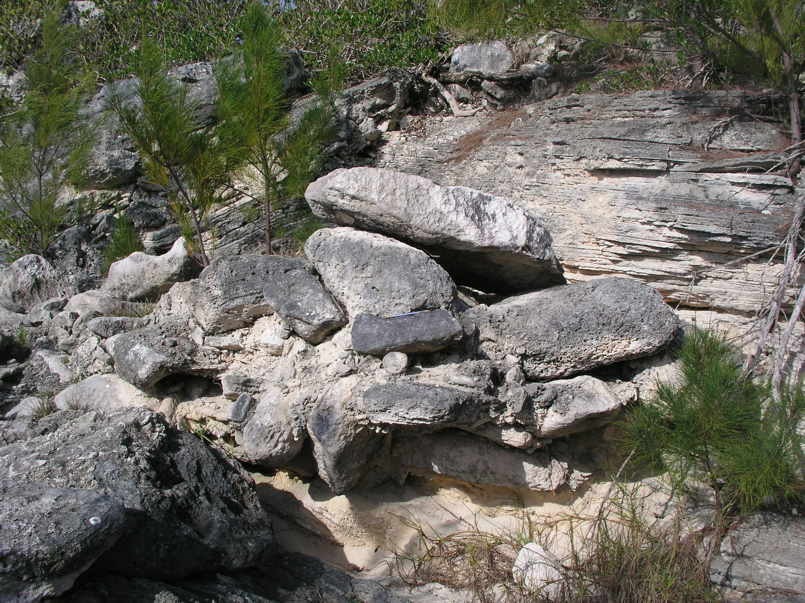
Interpretation of Section 9
This section, opposite Section 8, includes basal marine deposits which are not shown in the images above. Aeolian deposits of the Belmont formation dominate this section with landward dipping slip-face strata overlain by sub-horizontal topset strata separated by an intervening erosion surface. These aeolian deposits represent transition from a mobile landward-advancing dune to a stabilised sand-storing body probably associated with vegetation growth which trapped the sand on top of the dune. Truncating the dune-top strata is a seaward dipping erosion surface and notch (top right in the image, Section 9a). Displaced imbricated slabs of limestone resting on this surface and a large boulder in the notch attest to wave erosion associated with a post Belmont high sea level. No good age data from corals are available for this marine deposit. It is mapped as a member of the Rocky Bay formation because, stratigraphically, there is no other other credible option. Its previous identification as a new formation – “Spencer’s Point” (LA2) added unnecessary complexity to the stratigraphy based on observation at just this one locality. By identifying the dune as belonging to the Belmont formation and the marine deposit to the Rocky Bay formation the stratigraphy becomes consistent with the that observed at many lockabilities on Bermuda – for example Devonshire Bay and Hungry Bay. The justification given by early researchers for not adopting the most simplest interpretation, was that the succession observed here – of marine deposits followed by a protosol and a dune – was unique to the Rocky Bay formation and did not occur in the Belmont formation. However, by mapping the coastal geology from Spittal Pond to Devonshire Bay the author (MR) was able to show that this succession was, indeed, also present in the Belmont formation. It was concluded that the limestone outcrop along the entire length of coast at Spittal Pond (not just Spittal Pond West) should be assigned to the Belmont formation and sporadic patches of overlying marine conglomerates should be assigned to the Rocky Bay formation. This interpretation, as represented on the Geological Map of Bermuda (VA6), was subsequently corroborated by the discovery in 2014 ? of a coral in the marine unit near Section 2 which yielded a Belmont age of 197,000 years (RO4).
