

Summary
The length of the coastal exposure at the Whalebone Bay locality is approximately 180 m (0.1 miles). It is recommended that not less than 45 minutes be allowed to walk the route while following this guide.
Tightly cemented beach deposits thought to be of the Town Hill Formation occupy most of the northeastern shore of Whalebone Bay at Section 1 (See satellite image for section locations). A terra rossa palaeosol, which formed subsequent to the beach deposits at a lower sea level, has largely been stripped away. Evidence of its existence takes the form of occasional remnants of truncated soil pipes exposed on the eroded surface of ancient beach deposits. Next in the succession, at Section 2, are coarse weakly cemented beach sands, and locally a conglomerate, of the Rocky Bay Formation. This represents a rise in sea level approximately 120,000 years ago.
Overlying the coarse marine deposit is an immature brown palaeosol, or protosol, which slopes down to sea level towards the southwest. Last in the succession, is a Rocky Bay formation eolianite, representing a small dune which blew in from northwest towards the end of the Last Interglacial period during a fall in sea level.

Section descriptions
Section 1
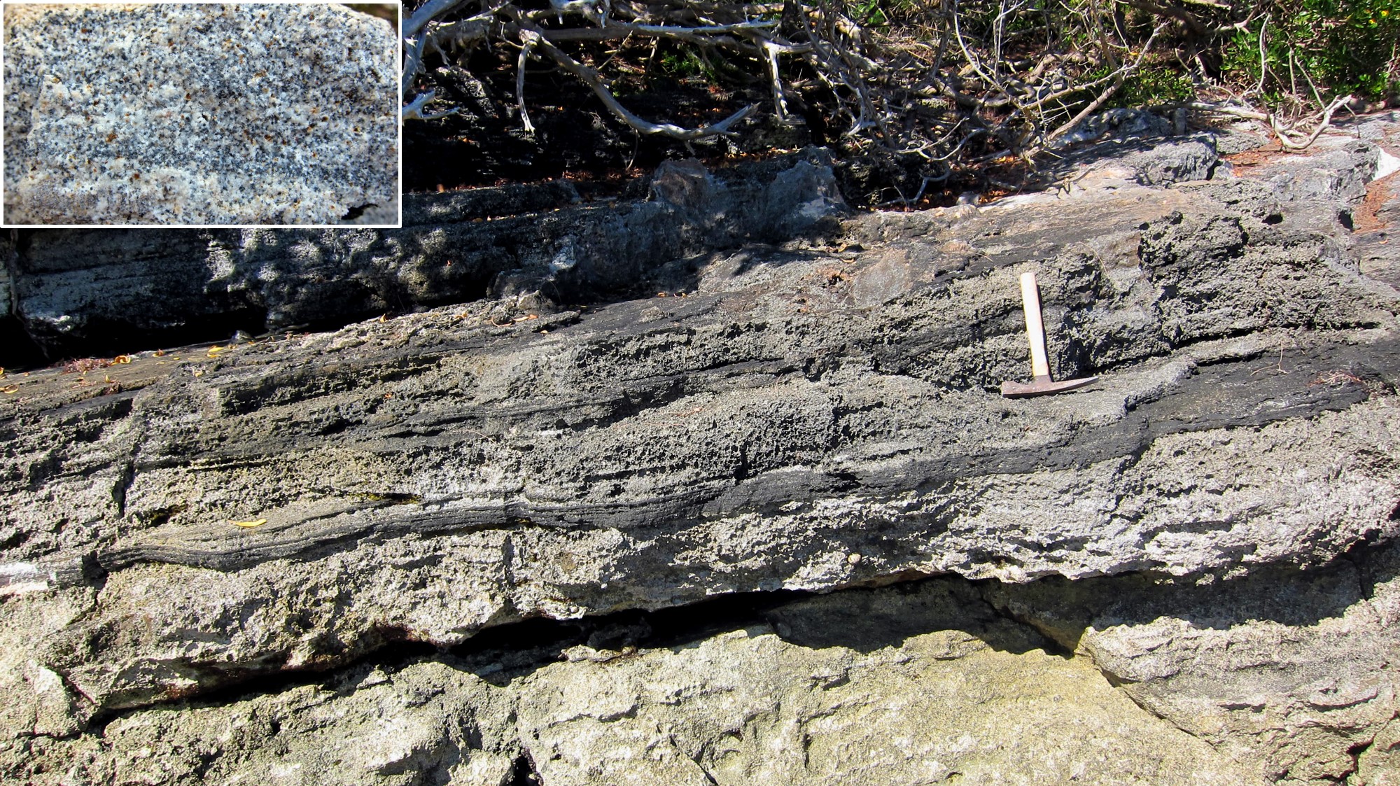
Planar strata, extending along the shore at Section 1, dip down to the northwest at approximately 10° . These deposits are interpreted as an ancient beach and are mapped as a member of the Town Hill Formation (VA6). A pre-Belmont age, is consistent with a later finding (VO4) that, based on their diagenetic history, the deposits must have been subjected to multiple submersions over a long period. Also indicative of age are thin layers of non-carbonate black volcanic sand within these deposits.

Interpretation of Section 1
Gently dipping parallel planar strata (Section 1) represent the swash zone of a beach which prograded towards northwest at a time when sea level was close to its present position. Deposits, close to present sea level, at the south-eastern end of the exposure, at the small beach, appear to be aeolian. This would suggest that the beach was formed contemperaneously with a marine transgression, as observed at other localities such as Devonshire Bay. Based on the occurrence of several phases of marine cementation (VO4), the beach is considered to be well over 200,000 years old i.e. pre-dating the Penultimate Interglacial period. It is inferred, from the inter-layered volcanic sand, that at the time of the beach’s deposition either remnants of the volcano were still exposed to wave erosion or sediment containing volcanic debris was being re-worked. More on the volcanic origins of Bermuda can be found in Chapter 2.
Section 2
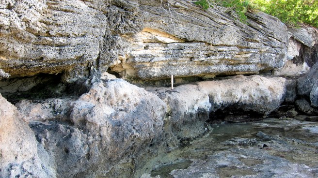
The beach deposits which occupy most of the north eastern shore of Whalebone Bay, at Section 1, extend westward and form the basal unit below the headland at Section 2. For the most part the terra rossa palaeosol which had overlain these beach deposits has been stripped away. Evidence of the soil’s existence is provided by truncated soil pipes. Weakly cemented marine sands with low angle near-horizontal stratification rest directly on the older beach. Large shell fragments and rounded limestone fragments are generally concentrated at the base of this younger marine limestone, which are interpreted as the marine member of the Rocky Bay Formation, traditionally known as the “Devonshire ” marine deposit.

The succession at Section 2 varies along its length. Towards the east, the Devonshire marine unit thins out until the overlying Harrington protosol rests directly on the old beach unit. Also, there are no dune deposits evident above the Harrington protosol at the eastern end of the section.
Towards the middle of Section 2, aeolian slip-face strata appear above the north-westward dipping protosol (Section 2b). These belong to a relatively small dome-shaped Rocky Bay dune which blew in from the north. Up-slope (to the east), well preserved fossil Poecilozonites land snails are quite common within the protosol. Down-slope (to the west) they are replaced by broken fragments of sea shells.
Continuing westward to the point of the headland (preferably at low tide) the sea-shell content of the protosol increases to the point that it could be characterised as a soily marine breccia or shell hash. The Devonshire marine unit which normally underlies the protosol, disappears or is incorporated into this breccia.
The full succession, at Section 2, replicates that at Rocky Bay (Section 7) except, the lowest beach unit in the succession at Whalebone Bay is thought not to be of the Belmont Formation but rather the older Town Hill Formation. As at Rocky Bay, the Devonshire marine sands are superposed by weak light coloured intra-formational soil, or protosol, named the “Harrington” followed by a Rocky Bay dune.
Interpretation of Section 2
A late Pleistocene rise in sea level, or marine transgression, removed remnants of a terra rossa palaeosol which had formed over the cemented beach-face deposits of Section 1. Coarse shelly material and carbonate sand were deposited by the sea on an erosional platform of the old beach-limestone (Figure 2a). These weakly cemented marine deposits are interpreted as part of the marine member of the Rocky Bay Formation, traditionally known as the Devonshire marine unit.
The protosol, which formed over the Devonshire marine unit, known as the Harrington, was the outcome of a fall in sea level or marine regression. It represents colonisation of the emergent marine deposits by vegetation. At this locality, the dune which tops the Rocky Bay succession is small. However, it is part of a substantial ridge of Rocky Bay dunes which extends north-eastward along the north-western shore of St. George’s island. It represents an island-wide dune-building event coincident with the end of the last major interglacial period (LIG).
A potential complication in this story is presented by the increasing content of marine shells, within the protosol, down-slope, in a westerly direction. This has been interpreted, by Bretz (BR1), as evidence of a second marine transgression which partially submerged the protosol and, through wave action, reworked it at low elevations. Alternative explanations are, first, that the intermingled soil and marine material are the result of bioturbation of the Harrington protosol and the subjacent Devonshire marine unit. A second explanation is that storm surges episodically mixed fresh marine material into the protosol during its accumulation. In these two circumstances, Bretz’s second sea level rise need not be invoked.
